IMAGES TAKEN NEAR TO
Dumyat Avenue, ALLOA, FK10 2RY
Introduction
This page details the photographs taken nearby to Dumyat Avenue, FK10 2RY by members of the Geograph project.
The Geograph project started in 2005 with the aim of publishing, organising and preserving representative images for every square kilometre of Great Britain, Ireland and the Isle of Man.

There are currently over 7.5m images from over14,400 individuals and you can help contribute to the project by visiting https://www.geograph.org.uk
Image Map
Images are licensed for reuse under creativecommons.org/licenses/by-sa/2.0
Notes
- Clicking on the map will re-center to the selected point.
- The higher the marker number, the further away the image location is from the centre of the postcode.
Image Listing (5 Images Found)
Images are licensed for reuse under creativecommons.org/licenses/by-sa/2.0
Image
Details
Distance
1
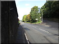
Road (A907) being joined by a road from Tullibody
Looking north-westward.
Image: © Peter Wood
Taken: 30 Sep 2017
0.21 miles
2
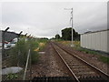
The railway to Stirling
Electrification masts installed but not yet the overhead.
Image: © Jonathan Thacker
Taken: 17 Aug 2018
0.22 miles
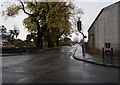
4
Tullibody
This is School Road in Tullibody one of many former mining villages in this area. The view is towards Myreton Hill.
Image: © Paul McIlroy
Taken: 24 Mar 2007
0.24 miles
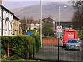
5

Ordnance Survey Flush Bracket G685
This bracket can be found on the wall of a building beside the A907 road between Cambus and Tullibody/ The benchmark height is recorded as being 10.412 metres above sea level. For more detail see : http://www.bench-marks.org.uk/bm17848
Image: © Peter Wood
Taken: 30 Sep 2017
0.25 miles