IMAGES TAKEN NEAR TO
Tullibody Road, ALLOA, FK10 2ES
Introduction
This page details the photographs taken nearby to Tullibody Road, FK10 2ES by members of the Geograph project.
The Geograph project started in 2005 with the aim of publishing, organising and preserving representative images for every square kilometre of Great Britain, Ireland and the Isle of Man.

There are currently over 7.5m images from over14,400 individuals and you can help contribute to the project by visiting https://www.geograph.org.uk
Image Map
Images are licensed for reuse under creativecommons.org/licenses/by-sa/2.0
Notes
- Clicking on the map will re-center to the selected point.
- The higher the marker number, the further away the image location is from the centre of the postcode.
Image Listing (6 Images Found)
Images are licensed for reuse under creativecommons.org/licenses/by-sa/2.0
Image
Details
Distance
1
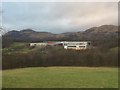
Lornshill Academy
View from Gubber Hill.
Image: © Richard Webb
Taken: 23 Jan 2020
0.08 miles
2
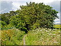
Path near Blackmuir Wood
A path near to Blackmuir Wood, Tullibody.
Image: © William Starkey
Taken: 14 Jul 2011
0.12 miles
3
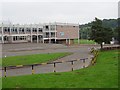
Lornshill Academy
School on the northern edge of Alloa.
Image: © Richard Webb
Taken: 16 Sep 2006
0.14 miles
4
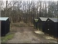
Garages beneath Gubber Hill
Woodland near Tullibody.
Image: © Richard Webb
Taken: 23 Jan 2020
0.22 miles
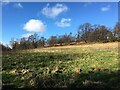
6

Woodland, Gubber Hill
A very pleasant woodland walk near Tullibody.
Image: © Richard Webb
Taken: 23 Jan 2020
0.24 miles