IMAGES TAKEN NEAR TO
Claremont, ALLOA, FK10 2DN
Introduction
This page details the photographs taken nearby to Claremont, FK10 2DN by members of the Geograph project.
The Geograph project started in 2005 with the aim of publishing, organising and preserving representative images for every square kilometre of Great Britain, Ireland and the Isle of Man.

There are currently over 7.5m images from over14,400 individuals and you can help contribute to the project by visiting https://www.geograph.org.uk
Image Map
Images are licensed for reuse under creativecommons.org/licenses/by-sa/2.0
Notes
- Clicking on the map will re-center to the selected point.
- The higher the marker number, the further away the image location is from the centre of the postcode.
Image Listing (8 Images Found)
Images are licensed for reuse under creativecommons.org/licenses/by-sa/2.0
Image
Details
Distance
1
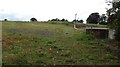
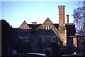
Alloa Academy site
The school has now moved to Forthbank and the buildings demolished.
Image: © Richard Webb
Taken: 2 Sep 2011
0.05 miles
2
Alloa Academy site
The buildings have been demolished after the school moved to a new site at Forthbank.
Image: © Richard Webb
Taken: 2 Sep 2011
0.06 miles
3
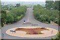
Roundabout
On the Alloa to Stirling road (A907) gives access to Alloa Technology Park.
Image: © Paul McIlroy
Taken: 8 Jun 2007
0.20 miles
4
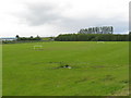
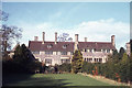
Playing field at Alloa
In the old county of Clackmannanshire.
Image: © James Denham
Taken: 28 May 2011
0.20 miles
7
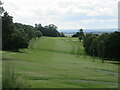
Braehead Golf Club, 7th Hole, Claremont
The seventh hole at Braehead, looking down the entire length of the hole to the green in the distance.
Image: © Scott Cormie
Taken: 29 Jun 2023
0.23 miles
8
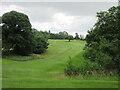
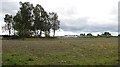
Braehead Golf Club, 9th Hole, Arn
The ninth hole at Braehead, looking from the tee up the hill to the distant green to the left of the lone tree.
Image: © Scott Cormie
Taken: 29 Jun 2023
0.23 miles