IMAGES TAKEN NEAR TO
Coats Crescent, ALLOA, FK10 2AQ
Introduction
This page details the photographs taken nearby to Coats Crescent, FK10 2AQ by members of the Geograph project.
The Geograph project started in 2005 with the aim of publishing, organising and preserving representative images for every square kilometre of Great Britain, Ireland and the Isle of Man.

There are currently over 7.5m images from over14,400 individuals and you can help contribute to the project by visiting https://www.geograph.org.uk
Image Map
Images are licensed for reuse under creativecommons.org/licenses/by-sa/2.0
Notes
- Clicking on the map will re-center to the selected point.
- The higher the marker number, the further away the image location is from the centre of the postcode.
Image Listing (7 Images Found)
Images are licensed for reuse under creativecommons.org/licenses/by-sa/2.0
Image
Details
Distance
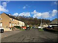
3

Woodland, Gubber Hill
A very pleasant woodland walk near Tullibody.
Image: © Richard Webb
Taken: 23 Jan 2020
0.19 miles
5
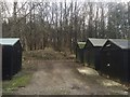
Garages beneath Gubber Hill
Woodland near Tullibody.
Image: © Richard Webb
Taken: 23 Jan 2020
0.20 miles
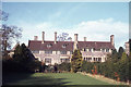
6
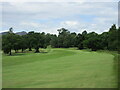
Braehead Golf Club, 10th Hole, Dunmar
The tenth hole at Braehead, looking to the green, with Dumyat just visible to the left.
Image: © Scott Cormie
Taken: 29 Jun 2023
0.23 miles
7
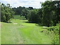
Braehead Golf Club, 6th Hole, Redwell
The short downhill sixth hole at Braehead from tee to green.
Image: © Scott Cormie
Taken: 29 Jun 2023
0.25 miles