IMAGES TAKEN NEAR TO
Dunlin Drive, ALLOA, FK10 1SH
Introduction
This page details the photographs taken nearby to Dunlin Drive, FK10 1SH by members of the Geograph project.
The Geograph project started in 2005 with the aim of publishing, organising and preserving representative images for every square kilometre of Great Britain, Ireland and the Isle of Man.

There are currently over 7.5m images from over14,400 individuals and you can help contribute to the project by visiting https://www.geograph.org.uk
Image Map
Images are licensed for reuse under creativecommons.org/licenses/by-sa/2.0
Notes
- Clicking on the map will re-center to the selected point.
- The higher the marker number, the further away the image location is from the centre of the postcode.
Image Listing (4 Images Found)
Images are licensed for reuse under creativecommons.org/licenses/by-sa/2.0
Image
Details
Distance
1
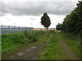
Path, Alloa
A path across marshy carse land near the Forth. Here it passes a gas valve compound.
The acronymn GVC on maps stands for Gas Valve Compound.
Image: © Richard Webb
Taken: 2 Sep 2011
0.16 miles
2
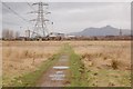
Alloa
Looking towards Alloa glass works and Dumyat.
Image: © Paul McIlroy
Taken: 16 Feb 2007
0.19 miles
3
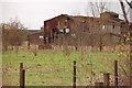
Derelict building
Derelict industrial building in the Bowhouse area of Alloa.
Image: © Paul McIlroy
Taken: 16 Feb 2007
0.22 miles
4
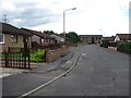
Riverside View, Alloa
No you cannot see a river, but you can certainly smell the sewage. The two bedroom house with the board was on the market for offers over £88,000.
Image: © Richard Webb
Taken: 2 Sep 2011
0.23 miles