IMAGES TAKEN NEAR TO
Pine Grove, ALLOA, FK10 1PZ
Introduction
This page details the photographs taken nearby to Pine Grove, FK10 1PZ by members of the Geograph project.
The Geograph project started in 2005 with the aim of publishing, organising and preserving representative images for every square kilometre of Great Britain, Ireland and the Isle of Man.

There are currently over 7.5m images from over14,400 individuals and you can help contribute to the project by visiting https://www.geograph.org.uk
Image Map
Images are licensed for reuse under creativecommons.org/licenses/by-sa/2.0
Notes
- Clicking on the map will re-center to the selected point.
- The higher the marker number, the further away the image location is from the centre of the postcode.
Image Listing (38 Images Found)
Images are licensed for reuse under creativecommons.org/licenses/by-sa/2.0
Image
Details
Distance
1
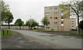
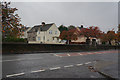
Flats on Devon Road
Seen from the junction with Turret Court.
Image: © Richard Sutcliffe
Taken: 18 May 2019
0.06 miles
2
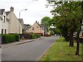
Clackmannan Road, Alloa
This was parkland on the 1940's map, now all housing.
Image: © Richard Webb
Taken: 4 Mar 2006
0.13 miles

4
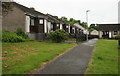
Single-storey housing, Turret Court, Alloa
Image: © Richard Sutcliffe
Taken: 18 May 2019
0.16 miles
7
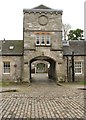
Clock tower, former stables of Alloa House
Built as the stables for Alloa House (a large house nearby, now demolished) about 1853 and Category B listed. Now converted for residential use.
Image: © Richard Sutcliffe
Taken: 18 May 2019
0.18 miles
8
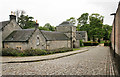
Former stables of Alloa House
Built as the stables for Alloa House (a large house nearby, now demolished) about 1853 and Category B listed. Now converted for residential use.
Image: © Richard Sutcliffe
Taken: 18 May 2019
0.18 miles
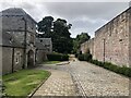
9
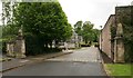
Cobbled road to Alloa Tower
The building on the left is the former stables of Alloa House (now demolished) and is Category B listed.
Image: © Richard Sutcliffe
Taken: 18 May 2019
0.18 miles
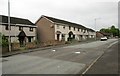
10
Earn Court
Sets on a road to Alloa Tower. The building on the left is the stable block for the big house that was here before 1960. They were restored at the same time as the tower and are now houses. A supermarket lurks behind the high wall.
Image: © Richard Webb
Taken: 24 Aug 2024
0.19 miles