IMAGES TAKEN NEAR TO
Otterton, BUDLEIGH SALTERTON, EX9 7JJ
Introduction
This page details the photographs taken nearby to EX9 7JJ by members of the Geograph project.
The Geograph project started in 2005 with the aim of publishing, organising and preserving representative images for every square kilometre of Great Britain, Ireland and the Isle of Man.

There are currently over 7.5m images from over14,400 individuals and you can help contribute to the project by visiting https://www.geograph.org.uk
Image Map
Images are licensed for reuse under creativecommons.org/licenses/by-sa/2.0
Notes
- Clicking on the map will re-center to the selected point.
- The higher the marker number, the further away the image location is from the centre of the postcode.
Image Listing (17 Images Found)
Images are licensed for reuse under creativecommons.org/licenses/by-sa/2.0
Image
Details
Distance
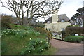
1
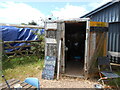
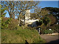
Stantyway farm Honesty cafe
A welcome break for walkers.
Instant coffee, tea and biscuits and flapjacks all excellently price.
Help yourself.
Image: © Anthony Vosper
Taken: 14 Jun 2024
0.00 miles
2
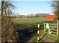
Stantyway playing fields, Otterton
Home to Otterton Football Club.
Image: © Roger Cornfoot
Taken: 1 Dec 2008
0.06 miles
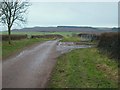
4
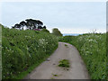
Stantyway Road
Looking south from beside Stantyway Farm.
Image: © Trevor Harris
Taken: 28 Mar 2015
0.06 miles
5
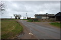
Stantyway Road
Looking along Image, with wide verges, in the opposite direction from near Stantyway Farm. Image leaves on the right, just this side of the gate.
Image: © Derek Harper
Taken: 15 Jan 2010
0.08 miles
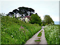
8
Monks Thatch
This and the house called Monks Wall stand on the old lane leading to Chiselbury Bay.
Image: © Trevor Harris
Taken: 28 Mar 2015
0.16 miles
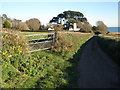
10
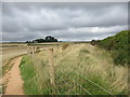
Diverted path
Looking towards Monks Wall.
The South West Coast Path has been slightly diverted here, away from a collapsing cliff face.
Image: © Jonathan Thacker
Taken: 13 Sep 2015
0.17 miles