IMAGES TAKEN NEAR TO
Chichester Way, BUDLEIGH SALTERTON, EX9 7ER
Introduction
This page details the photographs taken nearby to Chichester Way, EX9 7ER by members of the Geograph project.
The Geograph project started in 2005 with the aim of publishing, organising and preserving representative images for every square kilometre of Great Britain, Ireland and the Isle of Man.

There are currently over 7.5m images from over14,400 individuals and you can help contribute to the project by visiting https://www.geograph.org.uk
Image Map
Images are licensed for reuse under creativecommons.org/licenses/by-sa/2.0
Notes
- Clicking on the map will re-center to the selected point.
- The higher the marker number, the further away the image location is from the centre of the postcode.
Image Listing (58 Images Found)
Images are licensed for reuse under creativecommons.org/licenses/by-sa/2.0
Image
Details
Distance
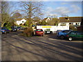
1
Looking up the High Street, East Budleigh
Image: © Roger Cornfoot
Taken: 24 Oct 2008
0.02 miles
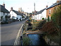
2
East Budleigh village hall
Budleigh brook runs in the foreground.
Image: © Anthony Vosper
Taken: 15 Jan 2012
0.02 miles
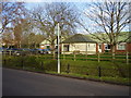
3
East Budleigh village shop
Situated in the grounds of the village hall I'm unsure how this venture works. It appears to be a community organised project.
Image: © Anthony Vosper
Taken: 15 Jan 2012
0.03 miles
4
Budleigh Brook in the High Street
This is a tributary of the much larger River Otter.
Image: © Anthony Vosper
Taken: 15 Jan 2012
0.04 miles
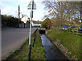
5
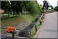
Roadside Stream
East Budleigh Village is fortunate to have a stream flowing alongside a part of the main road through the village. This makes a suitable stage to decorate with flowers.
Image: © Tony Atkin
Taken: 26 Jul 2010
0.04 miles
6
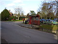
A choice of communicating in East Budleigh
By post,telephone and notice board or even take a bus ride.
Image: © Anthony Vosper
Taken: 15 Jan 2012
0.04 miles
7
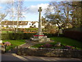
Remembering the fallen
East Budleigh, War Memorial in the High Street.
Image: © Anthony Vosper
Taken: 15 Jan 2012
0.04 miles
8
East Budleigh - site of toll house
Old photos show the traditionally shaped toll house was roughly where the car is in this photo. The end of this building had clearly been changed. The plaque on the wall records that the toll house was there until 1977 and the artist gives an impression of what the toll house looked like. Why might a toll house building sticking out into the street have been demolished? It is not often old buildings in such an old village as this are demolished.
Image: © Colin Vosper
Taken: 23 Dec 2007
0.05 miles
9

The 'Sir Walter Raleigh', East Budleigh
Image: © Roger Cornfoot
Taken: 24 Oct 2008
0.05 miles
10
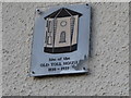
East Budleigh - site of toll house - commemorative plaque
Old photos show the toll house as part of the village street scene. The toll house jutted out into the road so that passing carts, people and cattle could be easily stopped and charged for using the road. Now only this plaque gives the passer-by any idea of what the building looked like.
Image: © Colin Vosper
Taken: 23 Dec 2007
0.05 miles