IMAGES TAKEN NEAR TO
Budleigh Hill, BUDLEIGH SALTERTON, EX9 7DT
Introduction
This page details the photographs taken nearby to Budleigh Hill, EX9 7DT by members of the Geograph project.
The Geograph project started in 2005 with the aim of publishing, organising and preserving representative images for every square kilometre of Great Britain, Ireland and the Isle of Man.

There are currently over 7.5m images from over14,400 individuals and you can help contribute to the project by visiting https://www.geograph.org.uk
Image Map
Images are licensed for reuse under creativecommons.org/licenses/by-sa/2.0
Notes
- Clicking on the map will re-center to the selected point.
- The higher the marker number, the further away the image location is from the centre of the postcode.
Image Listing (20 Images Found)
Images are licensed for reuse under creativecommons.org/licenses/by-sa/2.0
Image
Details
Distance
1
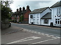
Houses and The Rolle Arms, East Budleigh looking towards Budleigh Salterton
Image: © Rob Purvis
Taken: 25 Apr 2009
0.03 miles

3

The Rolle Arms, East Budleigh
R132 KSF parked, YJI 5157 driving
Image: © Rob Purvis
Taken: 25 Apr 2009
0.06 miles
4

Frogmore Road bridge over Budleigh Brook, East Budleigh
Despite the appearance, the water flows through two corrugated pipes, not through arches
Image: © David Smith
Taken: 12 Aug 2019
0.07 miles
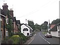
6
Frogmore Road, East Budleigh
The eastern edge of the village; these houses are to the right (east) of those shown in Image
Image: © Derek Harper
Taken: 11 Jul 2011
0.10 miles
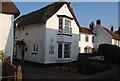
7

Cottages in Frogmore Road, East Budleigh
Image: © Roger Cornfoot
Taken: 24 Oct 2008
0.10 miles

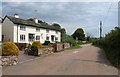
10
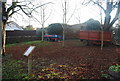
The pound, East Budleigh
This area was used to round up and keep animals.
Image: © N Chadwick
Taken: 30 Dec 2008
0.13 miles