IMAGES TAKEN NEAR TO
Hayes Lane, BUDLEIGH SALTERTON, EX9 7BS
Introduction
This page details the photographs taken nearby to Hayes Lane, EX9 7BS by members of the Geograph project.
The Geograph project started in 2005 with the aim of publishing, organising and preserving representative images for every square kilometre of Great Britain, Ireland and the Isle of Man.

There are currently over 7.5m images from over14,400 individuals and you can help contribute to the project by visiting https://www.geograph.org.uk
Image Map
Images are licensed for reuse under creativecommons.org/licenses/by-sa/2.0
Notes
- Clicking on the map will re-center to the selected point.
- The higher the marker number, the further away the image location is from the centre of the postcode.
Image Listing (8 Images Found)
Images are licensed for reuse under creativecommons.org/licenses/by-sa/2.0
Image
Details
Distance
1
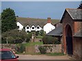
Hayes Barton, East Budleigh
The birthplace of Sir Walter Raleigh (or Ralegh)
Image: © David Smith
Taken: 22 Sep 2014
0.01 miles
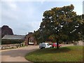
2
Hayes Barton - the birthplace of Sir Walter Raleigh
Image: © Sarah Charlesworth
Taken: 16 Dec 2008
0.02 miles
3

Hayes Barton
Birthplace of Sir Walter Raleigh.
Image: © Roger Cornfoot
Taken: 24 Oct 2008
0.03 miles
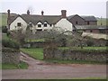
4
Archway to the farm at Hayes Barton
Hayes Barton, East Budleigh, is the birthplace of Sir Walter Raleigh. The farm buildings are constructed around a central square, reached through the arch
Image: © David Smith
Taken: 22 Sep 2014
0.05 miles
6
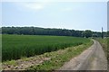
Wheat field, near Hayes Barton
Wheat field, near Hayes Barton, with Hayes Wood in the distance.
Image: © Kevin Hale
Taken: 7 Jun 2006
0.22 miles
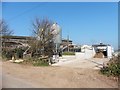
8
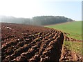
Freshly ploughed field below Hayes Wood
(A sea fret has rolled over the wood).
Image: © Roger Cornfoot
Taken: 27 Feb 2019
0.24 miles