IMAGES TAKEN NEAR TO
Kersbrook, BUDLEIGH SALTERTON, EX9 7AA
Introduction
This page details the photographs taken nearby to EX9 7AA by members of the Geograph project.
The Geograph project started in 2005 with the aim of publishing, organising and preserving representative images for every square kilometre of Great Britain, Ireland and the Isle of Man.

There are currently over 7.5m images from over14,400 individuals and you can help contribute to the project by visiting https://www.geograph.org.uk
Image Map
Images are licensed for reuse under creativecommons.org/licenses/by-sa/2.0
Notes
- Clicking on the map will re-center to the selected point.
- The higher the marker number, the further away the image location is from the centre of the postcode.
Image Listing (33 Images Found)
Images are licensed for reuse under creativecommons.org/licenses/by-sa/2.0
Image
Details
Distance

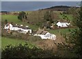
2
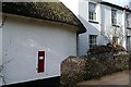
Kersbrook
One of just half a dozen houses in the hamlet of Kersbrook, dated by the Victorian postbox in the wall. There is a close up here Image]
Image: © Graham Horn
Taken: 25 Jan 2009
0.12 miles
3
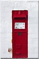
Kersbrook post box
A bright example of a Victorian post box in the hamlet of Kersbrook. In context it is here Image]
Image: © Graham Horn
Taken: 25 Jan 2009
0.12 miles
4
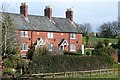
South Farm cottages
On the road to South Farm, on the first bit of higher land at the western edge of the floodplain. Despite looking very close this is actually taken across the four-way corner of four grid squares which intersect at the left hand end of the hedge.
Image: © Graham Horn
Taken: 25 Jan 2009
0.17 miles
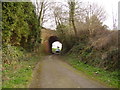
5
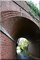
Kersbrook railway bridge
This very well constructed brick arched bridge originally carried the Exmouth Budleigh Honiton railway line, and this is the original road from Budleigh Salterton to East Budleigh. The railway is no longer used and the road has been bypassed. Yes the bridge still remains, as a tribute to the excellent brick workmanship of its makers.
Image: © Graham Horn
Taken: 25 Jan 2009
0.18 miles
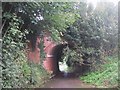
6
Disused railway bridge at Kersbrook
A footpath now runs along the trackway.
The roof and edge of the tunnel has some elaborate brickwork.
Image: © Anthony Vosper
Taken: 29 Feb 2012
0.18 miles
8
Kersbrook
Cottages on Kersbrook Lane, running alongside the tautologically-named Kersbrook Brook. The thatched C18 cottage is described as http://www.britishlistedbuildings.co.uk/en-87564-sauchenbush-1-budleigh-salterton . The hilltop wood is Tidwell Mount. From a footpath along the former railway line, where it diverges from East Budleigh Road.
Image: © Derek Harper
Taken: 21 Jan 2012
0.18 miles
9

Footpath steps at Kersbrook
This gives you access from the road onto the course of the old branch line railway that ran into Budleigh Salterton.
Image: © Anthony Vosper
Taken: 29 Feb 2012
0.18 miles
10
East Budleigh road, entering Budleigh Salterton, viewed from the junction with Granary Lane
W297 ROW entering Budleigh Salterton
Image: © Rob Purvis
Taken: 25 Apr 2009
0.19 miles