IMAGES TAKEN NEAR TO
Moormead, BUDLEIGH SALTERTON, EX9 6PZ
Introduction
This page details the photographs taken nearby to Moormead, EX9 6PZ by members of the Geograph project.
The Geograph project started in 2005 with the aim of publishing, organising and preserving representative images for every square kilometre of Great Britain, Ireland and the Isle of Man.

There are currently over 7.5m images from over14,400 individuals and you can help contribute to the project by visiting https://www.geograph.org.uk
Image Map
Images are licensed for reuse under creativecommons.org/licenses/by-sa/2.0
Notes
- Clicking on the map will re-center to the selected point.
- The higher the marker number, the further away the image location is from the centre of the postcode.
Image Listing (31 Images Found)
Images are licensed for reuse under creativecommons.org/licenses/by-sa/2.0
Image
Details
Distance
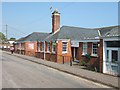
1

Site of drill hall in Moor Lane
The corrugated iron drill hall was demolished in October 2011.
Image: © John M
Taken: 13 Sep 2014
0.08 miles
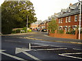
2

Moormead, Budleigh Salterton
The road (Moormead) is in two parts, with an open space with grass and trees in between.
Image: © David Smith
Taken: 16 May 2010
0.09 miles
3
St Peter's primary school, Budleigh Salterton
The school is Church of England (Aided)
Image: © David Smith
Taken: 23 Apr 2011
0.09 miles
4

At the end of Bedlands Lane opposite the front of St Peter's primary school
Image: © Rob Purvis
Taken: 4 May 2013
0.11 miles
5

Spooky Roots
Roots of a tree that protrude from the side of a very narrow steep sided lane.
Image: © Face
Taken: 27 Aug 2009
0.13 miles
6
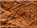
Bee Bank
Holes made in the Devon clay banks Found in Dark Lane Budleigh Salterton
Image: © Face
Taken: 11 Aug 2010
0.14 miles
7

Thatched Cottages in Little Knowle
Image: © Sarah Charlesworth
Taken: 9 Sep 2008
0.16 miles
8
Normans Close
Named not after William Duke of Normandy but after the Norman family who built one of East Devon's first Cash and Carry warehouses that stood on the site of the new builds.
Image: © Anthony Vosper
Taken: 28 Oct 2010
0.16 miles
9

Clinton Terrace
Named after the Clinton family, one of the major landowners in the area.
Image: © Anthony Vosper
Taken: 28 Oct 2010
0.17 miles
10

Capped off
A Sewage vent pipe has been cut off at its stump in Knowle Road.
Image: © Anthony Vosper
Taken: 13 Apr 2011
0.18 miles