IMAGES TAKEN NEAR TO
Stoneborough Lane, BUDLEIGH SALTERTON, EX9 6JA
Introduction
This page details the photographs taken nearby to Stoneborough Lane, EX9 6JA by members of the Geograph project.
The Geograph project started in 2005 with the aim of publishing, organising and preserving representative images for every square kilometre of Great Britain, Ireland and the Isle of Man.

There are currently over 7.5m images from over14,400 individuals and you can help contribute to the project by visiting https://www.geograph.org.uk
Image Map
Images are licensed for reuse under creativecommons.org/licenses/by-sa/2.0
Notes
- Clicking on the map will re-center to the selected point.
- The higher the marker number, the further away the image location is from the centre of the postcode.
Image Listing (104 Images Found)
Images are licensed for reuse under creativecommons.org/licenses/by-sa/2.0
Image
Details
Distance
1
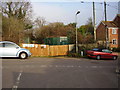
Electricity sub station, Granary Lane
The fencing doubles up as a community notice board.
Image: © Anthony Vosper
Taken: 29 Feb 2012
0.06 miles
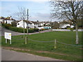
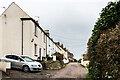
2

Housing Estate on the Edge of Budleigh Salterton
Image: © William Fairbrother
Taken: 17 Aug 2014
0.07 miles

4

Footpath beside Budleigh Salterton Cricket Club
Image: © David Smith
Taken: 2 Sep 2010
0.09 miles
5
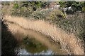
No longer the Otter
At one time this stream would have been part of the wide estuary of the River Otter. Following the formation of the Budleigh Salterton shingle bank, the main river now only flows along the eastern side of the flood plain. This stream is all that remains of the river on the western side.
Image: © Graham Horn
Taken: 25 Jan 2009
0.09 miles
7

Footpath by Lower Otter Wetlands
A new path by the freshly flooded wetlands in the restoration project
Image: © David Smith
Taken: 20 Oct 2023
0.11 miles
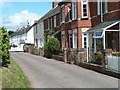
9
Granary Lane
Victorian terraced housing on Granary Lane. The 1889 1:2,500 map marks the near terrace as Jersey Cottages and that beyond as Otter View.
Image: © Ian Capper
Taken: 10 Feb 2020
0.12 miles
10

Estuary View, Budleigh Salterton
The estuary is that of the River Otter
Image: © David Smith
Taken: 2 Sep 2010
0.13 miles