IMAGES TAKEN NEAR TO
Boucher Way, BUDLEIGH SALTERTON, EX9 6HQ
Introduction
This page details the photographs taken nearby to Boucher Way, EX9 6HQ by members of the Geograph project.
The Geograph project started in 2005 with the aim of publishing, organising and preserving representative images for every square kilometre of Great Britain, Ireland and the Isle of Man.

There are currently over 7.5m images from over14,400 individuals and you can help contribute to the project by visiting https://www.geograph.org.uk
Image Map
Images are licensed for reuse under creativecommons.org/licenses/by-sa/2.0
Notes
- Clicking on the map will re-center to the selected point.
- The higher the marker number, the further away the image location is from the centre of the postcode.
Image Listing (140 Images Found)
Images are licensed for reuse under creativecommons.org/licenses/by-sa/2.0
Image
Details
Distance
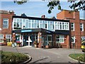
1

Budleigh Salterton hospital and car park
Image: © David Smith
Taken: 2 Sep 2010
0.04 miles
2

Estuary View, Budleigh Salterton
The estuary is that of the River Otter
Image: © David Smith
Taken: 2 Sep 2010
0.04 miles
3
Entrance of Budleigh Salterton hospital
Two nice pots of flowers to brighten the entrance, but what happened to the sign?
Image: © David Smith
Taken: 2 Sep 2010
0.06 miles
4

Coastguard Road
A street in Budleigh Salterton.
Image: © James Allan
Taken: 30 Apr 2015
0.11 miles
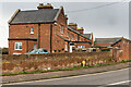
5

Coastguard Road
Buildings in Coastguard Road. On the far right is White Lodge, a 1970s development of 6 flats, and beyond is Chandlers House, a development of 6 flats built around 2000 with a design mimicking the former coastguard accommodation seen in the background (see Image).
Image: © Ian Capper
Taken: 10 Feb 2020
0.12 miles
6
20 - 34 Coastguard Road
Former coastguard station and associated accommodation, built in 1873. Grade II listed - see www.historicengland.org.uk/listing/the-list/list-entry/1393647.
Image: © Ian Capper
Taken: 10 Feb 2020
0.13 miles
7

34 and 36 - 38 Coastguard Road
Former coastguard station and associated accommodation, built in 1873. Grade II listed - see www.historicengland.org.uk/listing/the-list/list-entry/1393647.
Image: © Ian Capper
Taken: 10 Feb 2020
0.14 miles
8
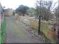
Footpath below Coastguard Road
This footpath runs between Coastguard Road and the coast, and provides a quiet path between the two. The wall on the right has an unusual fancy cap.
Image: © David Smith
Taken: 21 Feb 2010
0.15 miles

10
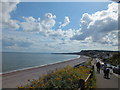
Budleigh Salterton
Looking at the town from the Marine Parade
Image: © Raymond Cubberley
Taken: 23 Jun 2011
0.16 miles