IMAGES TAKEN NEAR TO
Copp Hill Lane, BUDLEIGH SALTERTON, EX9 6DR
Introduction
This page details the photographs taken nearby to Copp Hill Lane, EX9 6DR by members of the Geograph project.
The Geograph project started in 2005 with the aim of publishing, organising and preserving representative images for every square kilometre of Great Britain, Ireland and the Isle of Man.

There are currently over 7.5m images from over14,400 individuals and you can help contribute to the project by visiting https://www.geograph.org.uk
Image Map
Images are licensed for reuse under creativecommons.org/licenses/by-sa/2.0
Notes
- Clicking on the map will re-center to the selected point.
- The higher the marker number, the further away the image location is from the centre of the postcode.
Image Listing (20 Images Found)
Images are licensed for reuse under creativecommons.org/licenses/by-sa/2.0
Image
Details
Distance
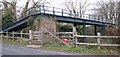
2
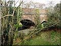
Bridge across the former branch line to Tipton St John
Image: © Roger Cornfoot
Taken: 26 Feb 2009
0.09 miles
3

The line stops here
The course of the old railway comes to an abrupt end.
New buildings on the other side of the bridge mean.This really is the end of the line.
Image: © Anthony Vosper
Taken: 23 Jan 2014
0.09 miles
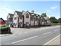
5

Upper Stoneborough Lane at Westfield Close
Image: © John Firth
Taken: 10 Jun 2014
0.12 miles
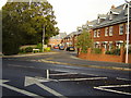
6

Budleigh Salterton Station
View SE, towards Tipton St Johns and Sidmouth Junction; ex-London & South Western, Sidmouth Jct. - Tipton St Johns - Exmouth line, closed entirely on 6/3/67.
Image: © Ben Brooksbank
Taken: 20 Apr 1964
0.12 miles
7

Over the bridge
Greenway lane uses a footbridge to cross the now disused railway line into Budleigh Salterton.
Image: © Anthony Vosper
Taken: 11 Feb 2023
0.13 miles
8

Clinton Terrace
Named after the Clinton family, one of the major landowners in the area.
Image: © Anthony Vosper
Taken: 28 Oct 2010
0.15 miles
9
Normans Close
Named not after William Duke of Normandy but after the Norman family who built one of East Devon's first Cash and Carry warehouses that stood on the site of the new builds.
Image: © Anthony Vosper
Taken: 28 Oct 2010
0.15 miles
10
Footbridge at Budleigh Salterton
This footbridge used to cross the line by Budleigh Salterton Station.
Image: © Sarah Charlesworth
Taken: 21 Dec 2008
0.16 miles