IMAGES TAKEN NEAR TO
Brook Road, BUDLEIGH SALTERTON, EX9 6AY
Introduction
This page details the photographs taken nearby to Brook Road, EX9 6AY by members of the Geograph project.
The Geograph project started in 2005 with the aim of publishing, organising and preserving representative images for every square kilometre of Great Britain, Ireland and the Isle of Man.

There are currently over 7.5m images from over14,400 individuals and you can help contribute to the project by visiting https://www.geograph.org.uk
Image Map
Images are licensed for reuse under creativecommons.org/licenses/by-sa/2.0
Notes
- Clicking on the map will re-center to the selected point.
- The higher the marker number, the further away the image location is from the centre of the postcode.
Image Listing (251 Images Found)
Images are licensed for reuse under creativecommons.org/licenses/by-sa/2.0
Image
Details
Distance
3
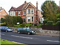
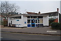
Budleigh Salterton, Dental Practice
Originally built as a pre war home this building is now home to a team of dentists.
Image: © Anthony Vosper
Taken: 28 Oct 2010
0.02 miles
4

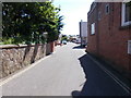
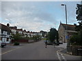
Stream in Budleigh Salterton
This stream runs parallel to the High Street. It enters a culvert and runs under "Brook Street" (there is a motor-cycle there in this picture). Closer to the sea, the stream runs in the open and can be seen from the High Street.
Image: © David Smith
Taken: 15 May 2010
0.02 miles
5
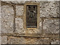
O S Flush Bracket,St Peter's Church
No: G5050 situated on the west wall.
Image: © Anthony Vosper
Taken: 4 Jul 2012
0.02 miles
6
Budleigh Salterton : The Lawn, Church & Houses
Image: © Lewis Clarke
Taken: 6 Sep 2009
0.02 miles
7
Pillar box at The Lawn
The adjacent footpath links up to Station road. Providing a short cut to the local library.
The main Post Office was just a short walk to the left of this photograph.
Like many it has now closed.
Image: © Anthony Vosper
Taken: 21 Jan 2022
0.02 miles
8

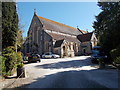
St Peter's church, Budleigh Salterton
The grey limestone church was built in 1891-3 "G H Fellowes Prynne in a free Early English style" http://www.britishlistedbuildings.co.uk/en-87567-church-of-st-peter-budleigh-salterton . Rather genteelly, the road it stands beside is The Lawn. Taken from what must be one of Devon's shorter footpaths, Budleigh Salterton Footpath 62, clocking in at about 17 metres.
Image: © Derek Harper
Taken: 9 Jul 2010
0.02 miles