IMAGES TAKEN NEAR TO
Meeting Lane, EXMOUTH, EX8 5JJ
Introduction
This page details the photographs taken nearby to Meeting Lane, EX8 5JJ by members of the Geograph project.
The Geograph project started in 2005 with the aim of publishing, organising and preserving representative images for every square kilometre of Great Britain, Ireland and the Isle of Man.

There are currently over 7.5m images from over14,400 individuals and you can help contribute to the project by visiting https://www.geograph.org.uk
Image Map
Images are licensed for reuse under creativecommons.org/licenses/by-sa/2.0
Notes
- Clicking on the map will re-center to the selected point.
- The higher the marker number, the further away the image location is from the centre of the postcode.
Image Listing (13 Images Found)
Images are licensed for reuse under creativecommons.org/licenses/by-sa/2.0
Image
Details
Distance
1

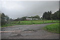
Entrance to Quaker burial ground, Gulliford
Quakers do not believe that meeting for worship should occur in any special place but in 1689 the first Chapel was established at Gulliford This was later demolished and its successor was also later destroyed.
Quakers have always reserved the word church to mean the body of people who make up the worshiping community: Quakers do not use the word church to refer to the bricks and mortar of a worshiping community. George Fox, an early Quaker, spoke of places of worship that have steeples as steeple houses, and those that do not as meeting houses.
On this site was a meeting house:
All that remains today is the walled cemetery with impressive gate piers.
The Ground has been described as having an atmosphere of gentle melancholy and decay.
The ground is open to the public.
Today the Ground is managed by the Gulliford Joint Committee: - a committee made up of members from Lympstone and Woodbury Parish Councils.
Image: © Anthony Vosper
Taken: 9 Mar 2014
0.01 miles
2

Gulliford Dissenters' cemetery
A short history can be found at https://www.lympstone.org/general-news/short-history-gulliford-burial-ground
Image: © Jonathan Thacker
Taken: 7 Oct 2022
0.02 miles
3

Table tombs. Gulliford Dissenters' Cemetery
A brief history of the cemetery can be found at https://www.lympstone.org/general-news/short-history-gulliford-burial-ground
Image: © Jonathan Thacker
Taken: 7 Oct 2022
0.02 miles
4

Gravestones in Gulliford burial ground
This Quaker burial ground is described in Image
Image: © David Smith
Taken: 11 Apr 2017
0.03 miles
5

In Gulliford burial ground
The history of this Quaker burial ground is described in Image
Image: © David Smith
Taken: 11 Apr 2017
0.04 miles
6
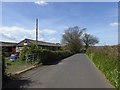
Meeting Lane, Lympstone
The lane takes its name from the site of the Quaker Meeting at Gulliford, where there is still a burial ground. There are stables by the gate
Image: © David Smith
Taken: 11 Apr 2017
0.05 miles

8
East Devon : Small Road
A small road heading off from the A376.
Image: © Lewis Clarke
Taken: 22 Oct 2013
0.16 miles
9

East Devon : Exmouth Road A376
Exmouth Road heading through East Devon. A caravan is being transported along the road.
Image: © Lewis Clarke
Taken: 22 Oct 2013
0.18 miles
10

Stagecoach Bus on Exmouth Road
Stagecoach Devon General Scania/Alexander Dennis Enviro double decker bus (15252, YN65 XDR) carrying Stagecoach Gold branding, heading north on Exmouth Road (A376) at Lympstone, on the Exmouth to Exeter service (57).
Image: © David Dixon
Taken: 23 Jul 2018
0.18 miles