IMAGES TAKEN NEAR TO
Trafalgar Road, EXMOUTH, EX8 5HX
Introduction
This page details the photographs taken nearby to Trafalgar Road, EX8 5HX by members of the Geograph project.
The Geograph project started in 2005 with the aim of publishing, organising and preserving representative images for every square kilometre of Great Britain, Ireland and the Isle of Man.

There are currently over 7.5m images from over14,400 individuals and you can help contribute to the project by visiting https://www.geograph.org.uk
Image Map
Images are licensed for reuse under creativecommons.org/licenses/by-sa/2.0
Notes
- Clicking on the map will re-center to the selected point.
- The higher the marker number, the further away the image location is from the centre of the postcode.
Image Listing (47 Images Found)
Images are licensed for reuse under creativecommons.org/licenses/by-sa/2.0
Image
Details
Distance

2
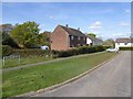
Edinburgh Crescent, Lympstone
A cul-de-sac (not a crescent) of two detached houses and three pairs of semi-detached houses dating from the mid 20th century
Image: © David Smith
Taken: 11 Apr 2017
0.10 miles

4

Field between Meeting Lane and Nutwell Road
The trees and wall beyond the field mark the boundary of Nutwell Park which surrounds Nutwell Lodge Image
Image: © David Smith
Taken: 11 Apr 2017
0.16 miles
5

Nutwell Road and a stone boundary marker
The inscription is illegible on this marker. On the left the wall is the boundary of Nutwell Court.
Image: © David Smith
Taken: 19 Jun 2011
0.17 miles
6
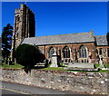
South side of Lympstone Parish Church
Viewed from Church Road. The nearby nameboard http://www.geograph.org.uk/photo/5227067 shows
LYMPSTONE PARISH CHURCH - The Nativity of the Blessed Virgin Mary.
Part of the Church of England Diocese of Exeter, the church seen here
is mostly the result of the 1864-67 rebuild. The tower dates from 1409.
There has been a church on this site since the 12th century.
The building was Grade II (star) listed in 1961.
Image: © Jaggery
Taken: 26 Aug 2016
0.18 miles
7
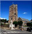
West side of Lympstone Parish Church
Viewed from Church Road across the corner of School Hill. The nearby nameboard http://www.geograph.org.uk/photo/5227067 shows
LYMPSTONE PARISH CHURCH - The Nativity of the Blessed Virgin Mary.
Part of the Church of England Diocese of Exeter, the church
seen here is mostly the result of the 1864-67 rebuild.
There has been a church on this site since the 12th century.
The tower dates from 1409. The building was Grade II (star) listed in 1961.
Image: © Jaggery
Taken: 26 Aug 2016
0.18 miles
8
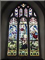
Memorial window in Lympstone church
This Victorian window shows the Annunciation (the angel's meeting with Mary, mother of Jesus) portrayed with Mary in a field with sheep!
Image: © David Smith
Taken: 19 Oct 2014
0.18 miles
9
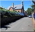
Lympstone Church Of England Primary School
Viewed across School Hill from near the corner of Church Road.
Image: © Jaggery
Taken: 26 Aug 2016
0.18 miles