IMAGES TAKEN NEAR TO
Edinburgh Crescent, EXMOUTH, EX8 5HT
Introduction
This page details the photographs taken nearby to Edinburgh Crescent, EX8 5HT by members of the Geograph project.
The Geograph project started in 2005 with the aim of publishing, organising and preserving representative images for every square kilometre of Great Britain, Ireland and the Isle of Man.

There are currently over 7.5m images from over14,400 individuals and you can help contribute to the project by visiting https://www.geograph.org.uk
Image Map
Images are licensed for reuse under creativecommons.org/licenses/by-sa/2.0
Notes
- Clicking on the map will re-center to the selected point.
- The higher the marker number, the further away the image location is from the centre of the postcode.
Image Listing (10 Images Found)
Images are licensed for reuse under creativecommons.org/licenses/by-sa/2.0
Image
Details
Distance
1
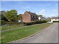
Edinburgh Crescent, Lympstone
A cul-de-sac (not a crescent) of two detached houses and three pairs of semi-detached houses dating from the mid 20th century
Image: © David Smith
Taken: 11 Apr 2017
0.02 miles

3

Nutwell Road and a stone boundary marker
The inscription is illegible on this marker. On the left the wall is the boundary of Nutwell Court.
Image: © David Smith
Taken: 19 Jun 2011
0.07 miles
4

Field between Meeting Lane and Nutwell Road
The trees and wall beyond the field mark the boundary of Nutwell Park which surrounds Nutwell Lodge Image
Image: © David Smith
Taken: 11 Apr 2017
0.08 miles

6
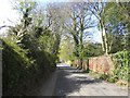
The boundary wall of Nutwell Park, Lympstone
A substantial wall surrounds the estate Image
Image: © David Smith
Taken: 11 Apr 2017
0.18 miles
7

Entrance gateway, Belvedere House
On Burgmann's Hill, Lympstone.
Image: © Roger Cornfoot
Taken: 31 Oct 2008
0.20 miles
8
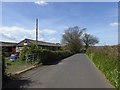
Meeting Lane, Lympstone
The lane takes its name from the site of the Quaker Meeting at Gulliford, where there is still a burial ground. There are stables by the gate
Image: © David Smith
Taken: 11 Apr 2017
0.21 miles
9
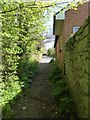
Footpath on the edge of Lympstone
The path leads from Nutwell Road to the foreshore, and, indirectly, to the Exe Estuary path
Image: © David Smith
Taken: 11 Apr 2017
0.24 miles
10

Nutwell Road
The road skirts Nutwell Park, bordered by the brick wall on the right, buttressed a little way ahead.
Image: © Derek Harper
Taken: 10 Dec 2010
0.25 miles