IMAGES TAKEN NEAR TO
Higher Marley Road, EXMOUTH, EX8 5DT
Introduction
This page details the photographs taken nearby to Higher Marley Road, EX8 5DT by members of the Geograph project.
The Geograph project started in 2005 with the aim of publishing, organising and preserving representative images for every square kilometre of Great Britain, Ireland and the Isle of Man.

There are currently over 7.5m images from over14,400 individuals and you can help contribute to the project by visiting https://www.geograph.org.uk
Image Map
Images are licensed for reuse under creativecommons.org/licenses/by-sa/2.0
Notes
- Clicking on the map will re-center to the selected point.
- The higher the marker number, the further away the image location is from the centre of the postcode.
Image Listing (17 Images Found)
Images are licensed for reuse under creativecommons.org/licenses/by-sa/2.0
Image
Details
Distance
1
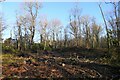
Bystock Wood, off Higher Marley Road, Exmouth
Image: © Tim Heaton
Taken: 7 Feb 2023
0.13 miles
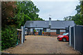
4

Lympstone : Uplands
Uplands on Hulham Road.
Image: © Lewis Clarke
Taken: 13 Jun 2020
0.19 miles
5
Lympstone : Marleycombe
Entrance to Marleycombe off Hulham Road.
Image: © Lewis Clarke
Taken: 13 Jun 2020
0.20 miles
6
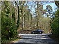
Car passing the north-east end of Marley Road
Image: © Rob Purvis
Taken: 13 Apr 2016
0.20 miles
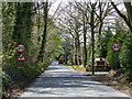
7
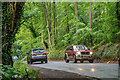
Exmouth : B3179
Looking along the B3179.
Image: © Lewis Clarke
Taken: 13 Jun 2020
0.20 miles
8
Lympstone : Pine Hollow
Looking to Pine Hollow off Hulham Road.
Image: © Lewis Clarke
Taken: 13 Jun 2020
0.21 miles
9

Lympstone : Hulham Road
Looking along Hulham Road.
Image: © Lewis Clarke
Taken: 13 Jun 2020
0.22 miles
10

Lympstone : Marley Drive
Looking along Marley Drive off Hulham Road.
Image: © Lewis Clarke
Taken: 13 Jun 2020
0.23 miles