IMAGES TAKEN NEAR TO
Marlborough Close, EXMOUTH, EX8 4NA
Introduction
This page details the photographs taken nearby to Marlborough Close, EX8 4NA by members of the Geograph project.
The Geograph project started in 2005 with the aim of publishing, organising and preserving representative images for every square kilometre of Great Britain, Ireland and the Isle of Man.

There are currently over 7.5m images from over14,400 individuals and you can help contribute to the project by visiting https://www.geograph.org.uk
Image Map
Images are licensed for reuse under creativecommons.org/licenses/by-sa/2.0
Notes
- Clicking on the map will re-center to the selected point.
- The higher the marker number, the further away the image location is from the centre of the postcode.
Image Listing (5 Images Found)
Images are licensed for reuse under creativecommons.org/licenses/by-sa/2.0
Image
Details
Distance
1
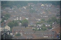
Exmouth : Exmouth Scenery
Looking across to the rooftops and houses of Exmouth.
Image: © Lewis Clarke
Taken: 13 Jun 2020
0.05 miles
2
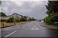
Exmouth : Parkside Drive
Looking along Parkside Drive.
Image: © Lewis Clarke
Taken: 13 Jun 2020
0.16 miles
3
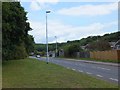
Dinan Way in the valley of the Withycombe Brook
Dinan Way crosses and recrosses the brook in this valley; the stream runs behind the houses
Image: © David Smith
Taken: 1 Jul 2011
0.17 miles
4
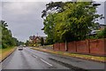
Exmouth : Dinan Way
Looking along Dinan Way.
Image: © Lewis Clarke
Taken: 13 Jun 2020
0.18 miles
