IMAGES TAKEN NEAR TO
Ashfield Close, EXMOUTH, EX8 4HE
Introduction
This page details the photographs taken nearby to Ashfield Close, EX8 4HE by members of the Geograph project.
The Geograph project started in 2005 with the aim of publishing, organising and preserving representative images for every square kilometre of Great Britain, Ireland and the Isle of Man.

There are currently over 7.5m images from over14,400 individuals and you can help contribute to the project by visiting https://www.geograph.org.uk
Image Map
Images are licensed for reuse under creativecommons.org/licenses/by-sa/2.0
Notes
- Clicking on the map will re-center to the selected point.
- The higher the marker number, the further away the image location is from the centre of the postcode.
Image Listing (20 Images Found)
Images are licensed for reuse under creativecommons.org/licenses/by-sa/2.0
Image
Details
Distance
1
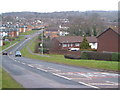
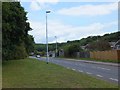
Dinan Way, Exmouth
A varied square including the edge of the Exmouth suburbs, the partly wooded valleys of the Withycombe Brook (at the foot of this hill) and its tributary, a business park and a trading estate, plus fields and other woods. Paramount among these is the Woodland Trust's Liverton Copse, a corner of which is visible on the near right, behind new housing. View looking north.
Image: © Derek Harper
Taken: 9 Mar 2006
0.01 miles
2
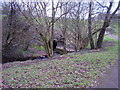
Withycombe Brook looking West
This links to a pedestrian subway and goes under Dinan Way.
Image: © Anthony Vosper
Taken: 24 Feb 2012
0.13 miles
3
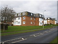
Blocks of flats, on Dinan Way, Exmouth
Image: © Roger Cornfoot
Taken: 10 Dec 2008
0.13 miles
4
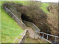
Withycombe Brook looking East
This follow a pedestrian subway and goes under Dinan Way.
Image: © Anthony Vosper
Taken: 24 Feb 2012
0.15 miles
5
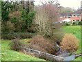
Withycombe Brook
Emerging from beneath Dinan Way, from which this was taken, and entering the trees shown in Image], with houses on Gibson Close.
Image: © Derek Harper
Taken: 9 Mar 2006
0.15 miles
6
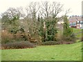
Trees by Dinan Way
And by the Withycombe Brook. The woodland would have formed part of Liverton Copse, but Dinan Way has separated it. The houses are on Gibson Close.
Image: © Derek Harper
Taken: 9 Mar 2006
0.15 miles
7
Edge of Liverton Copse
Seen across Dinan Way, with a path that seems to be running into the wood http://visitwoods.org.uk/en/visit-woods/Pages/wood-image-preview.aspx?wood=4054&site=Liverton-Copse&imageUid=ce0987fb-2df6-49ae-97e5-a01f59e99d63&source=OurWoods&__pageNumber=3#.UoJXBXDwlOI , but probably doesn't.
Image: © Derek Harper
Taken: 9 Mar 2006
0.16 miles
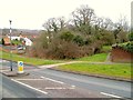
8
Dinan Way drops into the valley of the Withycombe Brook
Image: © Sarah Charlesworth
Taken: 5 Feb 2010
0.16 miles
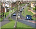
9
Dinan Way in the valley of the Withycombe Brook
Dinan Way crosses and recrosses the brook in this valley; the stream runs behind the houses
Image: © David Smith
Taken: 1 Jul 2011
0.16 miles
10
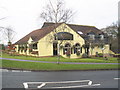
The Rumblin-Tum, Dinan Way, Exmouth
Image: © Roger Cornfoot
Taken: 10 Dec 2008
0.20 miles