IMAGES TAKEN NEAR TO
St. Johns Road, EXMOUTH, EX8 4GA
Introduction
This page details the photographs taken nearby to St. Johns Road, EX8 4GA by members of the Geograph project.
The Geograph project started in 2005 with the aim of publishing, organising and preserving representative images for every square kilometre of Great Britain, Ireland and the Isle of Man.

There are currently over 7.5m images from over14,400 individuals and you can help contribute to the project by visiting https://www.geograph.org.uk
Image Map
Images are licensed for reuse under creativecommons.org/licenses/by-sa/2.0
Notes
- Clicking on the map will re-center to the selected point.
- The higher the marker number, the further away the image location is from the centre of the postcode.
Image Listing (4 Images Found)
Images are licensed for reuse under creativecommons.org/licenses/by-sa/2.0
Image
Details
Distance
1
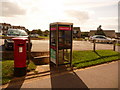
Exmouth: postbox № EX8 605, Brixington shops
This postbox is at Image, facing the door of the post office, on which a handwritten notice explained that the office would be closed this Saturday morning as well as the upcoming bank holiday Monday. The box is emptied finally on weekdays at 6pm and on Saturdays at 12:15pm.
Image: © Chris Downer
Taken: 29 Aug 2009
0.21 miles
2
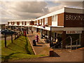
Exmouth: Brixington shops
A shopping parade in suburban Exmouth, comprising all the likely candidates: post office, general store, hairdresser, vacant premises – and the not so predictable stockist of wheelchairs and other mobility aids, nearest the camera.
Image: © Chris Downer
Taken: 29 Aug 2009
0.21 miles
3
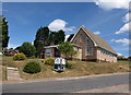
Brixington Community Church
This Baptist church set above Churchill Road opened in 1973, after considerable financial struggle http://www.bcc.saxton.org.uk/html/history.html .
Image: © Derek Harper
Taken: 9 Jul 2010
0.25 miles
4
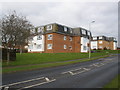
Blocks of flats, on Dinan Way, Exmouth
Image: © Roger Cornfoot
Taken: 10 Dec 2008
0.25 miles