IMAGES TAKEN NEAR TO
High View Gardens, EXMOUTH, EX8 2JR
Introduction
This page details the photographs taken nearby to High View Gardens, EX8 2JR by members of the Geograph project.
The Geograph project started in 2005 with the aim of publishing, organising and preserving representative images for every square kilometre of Great Britain, Ireland and the Isle of Man.

There are currently over 7.5m images from over14,400 individuals and you can help contribute to the project by visiting https://www.geograph.org.uk
Image Map
Images are licensed for reuse under creativecommons.org/licenses/by-sa/2.0
Notes
- Clicking on the map will re-center to the selected point.
- The higher the marker number, the further away the image location is from the centre of the postcode.
Image Listing (23 Images Found)
Images are licensed for reuse under creativecommons.org/licenses/by-sa/2.0
Image
Details
Distance
1

Exmouth Hospital chapel
claremont Grove,Exmouth.
Image: © Anthony Vosper
Taken: 26 Jun 2016
0.03 miles
2
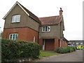
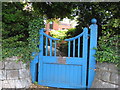
Exmouth hospital lodge
No offices and storage.
One may speculate that this was once the doctors house.
Image: © Anthony Vosper
Taken: 26 Jun 2016
0.05 miles
3
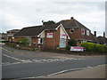
The Circle of Care
One of a number of care and home help agency's in Exmouth.
Image: © Anthony Vosper
Taken: 26 Jun 2016
0.05 miles
4
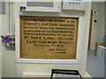
Exmouth Hospital dedication stone
This now is situated inside one of the wards.
Clear evidence of the expansion and growth of the hospital.
The gate can be seen through the ward window.
Image
Image: © Anthony Vosper
Taken: 29 Jun 2016
0.06 miles
5
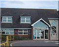
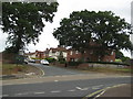
The Health Centre by Exmouth Hospital
Image: © Sarah Charlesworth
Taken: 7 Sep 2008
0.06 miles
6
The original hospital entrance
The path and steps no longer go to a doorway.
The original foundation stone, which must have been in the proximity of the main door,is now inside one of the wards.
This can be found Image
Image: © Anthony Vosper
Taken: 26 Jun 2016
0.07 miles

8
Oakleigh Road, Exmouth
Originally 1920's council houses.
The oaks appear to be still in place.
Image: © Anthony Vosper
Taken: 26 Jun 2016
0.10 miles
9
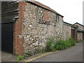
Raddenstile Lane. What was it originally?
A close up of possibly a farm building. Shows a blocked doorway with a large wooden lintel still in place.
Image: © Anthony Vosper
Taken: 26 Jun 2016
0.11 miles
10

Mystery building Raddenstile Lane
Whilst now a garage facing the main road.
This building originally had an entrance at the side.
See Image for a more detailed picture.
Image: © Anthony Vosper
Taken: 26 Jun 2016
0.11 miles