IMAGES TAKEN NEAR TO
Maer Vale, EXMOUTH, EX8 2DX
Introduction
This page details the photographs taken nearby to Maer Vale, EX8 2DX by members of the Geograph project.
The Geograph project started in 2005 with the aim of publishing, organising and preserving representative images for every square kilometre of Great Britain, Ireland and the Isle of Man.

There are currently over 7.5m images from over14,400 individuals and you can help contribute to the project by visiting https://www.geograph.org.uk
Image Map
Images are licensed for reuse under creativecommons.org/licenses/by-sa/2.0
Notes
- Clicking on the map will re-center to the selected point.
- The higher the marker number, the further away the image location is from the centre of the postcode.
Image Listing (30 Images Found)
Images are licensed for reuse under creativecommons.org/licenses/by-sa/2.0
Image
Details
Distance
1
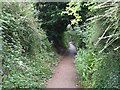
Lime Kiln Lane
Old sunken lane running inland from the site of the lime kilns on the Maer. Now used as a footpath.
Image: © Sarah Charlesworth
Taken: 5 Aug 2008
0.02 miles
2
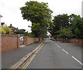
North along Cyprus Road, Exmouth
From Gordon Avenue along Cyprus Road towards Maer Vale and Salterton Road.
Image: © Jaggery
Taken: 16 Jul 2017
0.12 miles
3
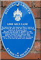
Lime Kiln Lane, Exmouth
On the wall to the left, the society "Historic Exmouth" has put up a plaque. It reads: "Lime Kiln Lane. This ancient lane, also known as Watery Lane, is named from the route to the 18th century lime kiln situated on the present Maer. The lane was also used by smugglers to take contraband from Orcombe Image to Mutter's cider shop formerly located on the Salterton Road Image Mutter was a local smuggler after whom Mutter's Moor Image was named which was the location of one of his look-out points near Sidmouth"
Image: © David Smith
Taken: 4 Nov 2013
0.15 miles
4
Cyprus Road, Exmouth
The southern end of Cyprus Road viewed across Douglas Avenue.
Image: © Jaggery
Taken: 16 Jul 2017
0.16 miles
5
Lime Kiln Lane blue plaque, Exmouth
Facing Douglas Avenue on a wall near the lane. http://www.geograph.org.uk/photo/5475967
Image: © Jaggery
Taken: 16 Jul 2017
0.17 miles
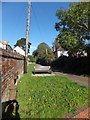
6
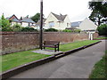
Lime Kiln Lane bench, Exmouth
On the north side of Douglas Avenue. A nearby blue plaque http://www.geograph.org.uk/photo/5475968 records that ancient Lime Kiln Lane, also known as Watery Lane, is so named from the route to the 18th century lime kiln situated on the present Maer. The lane was also used by smugglers to take contraband from Orcombe to Mutter's cider shop formerly located on the Salterton Road. Mutter was a local smuggler after whom Mutter's Moor was named which was the location of one of his lookout points near Sidmouth.
Image: © Jaggery
Taken: 16 Jul 2017
0.17 miles
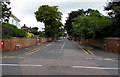
7
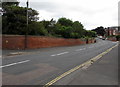
Towards a bend in Douglas Avenue, Exmouth
The bend is opposite the Maer Road junction.
Image: © Jaggery
Taken: 16 Jul 2017
0.17 miles
8

Devoncourt Hotel, Exmouth
From the Maer Road car park.
Image: © Derek Harper
Taken: 9 Mar 2006
0.18 miles
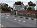
9

Maer Court Cottage, Exmouth
Maer Road side of the cottage on the corner of Douglas Avenue.
Image: © Jaggery
Taken: 16 Jul 2017
0.18 miles
10
Maer Court Cottage, Exmouth
Douglas Avenue side of the cottage on the corner of Maer Road.
Image: © Jaggery
Taken: 16 Jul 2017
0.18 miles