IMAGES TAKEN NEAR TO
Holman Close, DAWLISH, EX7 9TB
Introduction
This page details the photographs taken nearby to Holman Close, EX7 9TB by members of the Geograph project.
The Geograph project started in 2005 with the aim of publishing, organising and preserving representative images for every square kilometre of Great Britain, Ireland and the Isle of Man.

There are currently over 7.5m images from over14,400 individuals and you can help contribute to the project by visiting https://www.geograph.org.uk
Image Map
Images are licensed for reuse under creativecommons.org/licenses/by-sa/2.0
Notes
- Clicking on the map will re-center to the selected point.
- The higher the marker number, the further away the image location is from the centre of the postcode.
Image Listing (17 Images Found)
Images are licensed for reuse under creativecommons.org/licenses/by-sa/2.0
Image
Details
Distance
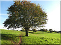
1

View towards Exnouth
From Dawlish footpath 14 at the top of a 100 metre hilltop, over the town's northern suburbs to Dawlish Warren and the Exe estuary, with Exmouth and the coast east to Straight Point on the right.
Image: © Derek Harper
Taken: 20 Oct 2019
0.09 miles
2
Path behind Dawlish Leisure Centre
The path crosses an open playing field towards Exeter Road.
Image: © Stephen Craven
Taken: 27 Oct 2019
0.14 miles
3

Sports pitch behind Dawlish Leisure Centre
A levelled area, presumably for ball games.
Image: © Stephen Craven
Taken: 27 Oct 2019
0.14 miles

5

Dawlish Leisure Centre
The swimming pool opened in 1974; in 1994 a sports hall was added and it became Dawlish Leisure Centre.
Image: © Stephen Craven
Taken: 27 Oct 2019
0.18 miles
6
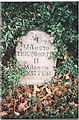
Old Milestone by the A379, Exeter Road, Dawlish parish
Carved stone post by the A379, in parish of DAWLISH (TEIGNBRIDGE District), 50m South of Springfield Gardens, by Lady's Mile Holiday Park, on the verge close to road, under holly hedge, on East side of road. Teignmouth granite stone, erected by the Teignmouth & Dawlish turnpike trust in the 19th century.
Inscription reads:-
4
Miles To
TEIGNMOUTH
11
Miles To
EXETER
Devon & Dartmoor HER.
HER Number: MDV70289 https://www.heritagegateway.org.uk/Gateway/Results_Single.aspx?uid=MDV70289&resourceID=104
Milestone Society National ID: DV_EXTG11.
Image: © T Jenkinson
Taken: 3 Dec 2003
0.21 miles
7
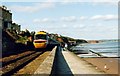
Dawlish Sea Wall
One of the most picturesque stretches of railway line in the UK. The large sandstone block in the distance is Langstone Rock.
Image: © Michael Parry
Taken: Unknown
0.22 miles
9

Lady's Mile Holiday Park
Looking across a grass field that adjoins the holiday park, from Warren Road, with Great Haldon in the distance.
Image: © Derek Harper
Taken: 13 Jul 2016
0.22 miles
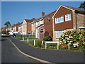
10

Junction on A379
The road to Dawlish Warren (Warren Road) leads away from the main road northwards out of Dawlish. Opposite the line of housing is Warren Copse.
Image: © Derek Harper
Taken: 11 Dec 2008
0.23 miles