IMAGES TAKEN NEAR TO
Copp Path, DAWLISH, EX7 9SR
Introduction
This page details the photographs taken nearby to Copp Path, EX7 9SR by members of the Geograph project.
The Geograph project started in 2005 with the aim of publishing, organising and preserving representative images for every square kilometre of Great Britain, Ireland and the Isle of Man.

There are currently over 7.5m images from over14,400 individuals and you can help contribute to the project by visiting https://www.geograph.org.uk
Image Map
Images are licensed for reuse under creativecommons.org/licenses/by-sa/2.0
Notes
- Clicking on the map will re-center to the selected point.
- The higher the marker number, the further away the image location is from the centre of the postcode.
Image Listing (41 Images Found)
Images are licensed for reuse under creativecommons.org/licenses/by-sa/2.0
Image
Details
Distance
1
Richards Close, Dawlish
One of several housing developments, all painted white, clustered around John Nash Drive.
Image: © Robin Stott
Taken: 9 Jun 2009
0.04 miles
2
Williams Close, Dawlish
The developer of this white-painted estate has shown a jaw-dropping degree of sympathy for the terrain. Properties on the other side of the abyss are in SX9575.
Image: © Robin Stott
Taken: 9 Jun 2009
0.04 miles
3
Summerhayes, off John Nash Drive, Dawlish
By shoehorning the dwellings in on challenging terrain, and using an all-white colour scheme, the developer has created an appealing estate with a Mediterranean feel. But what is it like to live here, to slog up and down all those slopes?
Image: © Robin Stott
Taken: 27 Jun 2009
0.08 miles
4
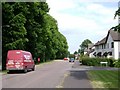
Dawlish : John Nash Drive
A road which leads from Oak Hill towards Teignmouth Road.
Image: © Lewis Clarke
Taken: 27 Mar 2011
0.12 miles
5
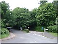
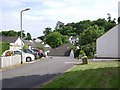
John Nash Drive, Dawlish (1)
Entrances to two schools: Ratcliffe School, left; Oaklands Park School, right, both tucked away in woodland. A glimpse of outbuildings at Oaklands is Image
Image: © Robin Stott
Taken: 27 Jun 2009
0.12 miles
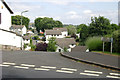
7
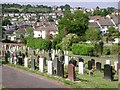
Looking across Third Avenue from Dawlish Cemetery
Image: © Robin Stott
Taken: 9 Jun 2009
0.12 miles
9
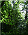
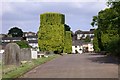
Woodland by Shillingate Close, Dawlish
This is the woodland that appears in Image and along much of the south side of John Nash Drive.
Image: © Robin Stott
Taken: 27 Jun 2009
0.13 miles
10

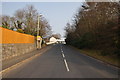
Dawlish : Oak Hill
Looking down Oak Hill which enters Dawlish from Teignmouth.
Image: © Lewis Clarke
Taken: 27 Mar 2011
0.14 miles