IMAGES TAKEN NEAR TO
Exeter Road, DAWLISH, EX7 9JW
Introduction
This page details the photographs taken nearby to Exeter Road, EX7 9JW by members of the Geograph project.
The Geograph project started in 2005 with the aim of publishing, organising and preserving representative images for every square kilometre of Great Britain, Ireland and the Isle of Man.

There are currently over 7.5m images from over14,400 individuals and you can help contribute to the project by visiting https://www.geograph.org.uk
Image Map
Images are licensed for reuse under creativecommons.org/licenses/by-sa/2.0
Notes
- Clicking on the map will re-center to the selected point.
- The higher the marker number, the further away the image location is from the centre of the postcode.
Image Listing (828 Images Found)
Images are licensed for reuse under creativecommons.org/licenses/by-sa/2.0
Image
Details
Distance
1

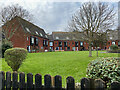
Entrance to Lanherne, Dawlish
Lanherne is a sheltered housing complex managed by Teign Housing. It takes the name of the house on whose site it was built, originally Sea Grove, a Regency villa, later Blyth. The old stone gate pillars bear its final name, Lanherne.
Image: © Robin Stott
Taken: 20 Mar 2022
0.00 miles
2
Lanherne sheltered housing, Dawlish
Also described as retirement housing, it is managed by Teign Housing https://housingcare.org/housing-care/facility-info-82014-lanherne-dawlish-england It occupies the site of a Regency villa. Some history is given here http://www.dawlishhistory.org.uk/maps/Trails/Location%206.htm This account notes that the original name of the house was Sea Grove and that it was renamed Lanherne in 1916. A house of the same planform is named Blyth on a map of 1892-1914. The view is from Thompson's Path.
Image: © Robin Stott
Taken: 20 Mar 2022
0.01 miles
3
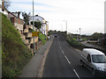
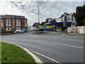
Ascending Exeter Road out of Dawlish
The A379 Exeter Road leaves Dawlish by a series of sharp bends; seen from the top deck of a No 2 bus.
Image: © Robin Stott
Taken: 11 Dec 2009
0.01 miles
4

Dawlish : Lanherne
Sheltered accommodation in Dawlish.
Image: © Lewis Clarke
Taken: 20 Jul 2015
0.01 miles
5
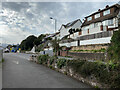
Exeter Road north of Lanherne, Dawlish
Lanherne sheltered housing is out of shot left.
Image: © Robin Stott
Taken: 20 Mar 2022
0.02 miles
6

Buttressed wall against Exeter Road, Dawlish
Exeter Road is on the other side of the wall, left. A town plan, 1880s-90s, shows that this and the whole area out of shot right Image was the kitchen garden to the house known at different times as Sea Grove, Blyth, and Lanherne. Sheltered housing has taken its place and its name. Where this path is there were greenhouses against the wall (which may have been rebuilt).
Image: © Robin Stott
Taken: 20 Mar 2022
0.03 miles
7
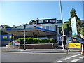
Dawlish : 2'n'4 Repair Centre
The car repair centre on Exeter Road in Dawlish.
Image: © Lewis Clarke
Taken: 16 Jun 2010
0.03 miles
8
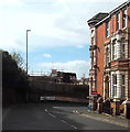
High Street turning off Exeter Road, Dawlish
'Dawlish 2 'n' 4 Repair Centre' looks as though it was once a petrol filling station. On the left is the north end of Iddesleigh Terrace Image and Image
Image: © Robin Stott
Taken: 20 Mar 2022
0.04 miles
9
Sharp bend in Iddesleigh Terrace, Dawlish
Directions to Exeter are painted on the wall ahead.
Image: © John C
Taken: 28 Apr 2018
0.04 miles
10

Footpath parallel to the Exeter Road, Dawlish
Exeter Road is on the other side of the wall, right. A town plan, 1880s-90s, shows that this whole area was the kitchen garden to the house known at different times as Sea Grove, Blyth, and Lanherne, from which the sheltered housing, left, takes its name. Where this path is there were greenhouses against the wall.
Image: © Robin Stott
Taken: 20 Mar 2022
0.04 miles