IMAGES TAKEN NEAR TO
West Cliff Park Drive, DAWLISH, EX7 9EL
Introduction
This page details the photographs taken nearby to West Cliff Park Drive, EX7 9EL by members of the Geograph project.
The Geograph project started in 2005 with the aim of publishing, organising and preserving representative images for every square kilometre of Great Britain, Ireland and the Isle of Man.

There are currently over 7.5m images from over14,400 individuals and you can help contribute to the project by visiting https://www.geograph.org.uk
Image Map
Images are licensed for reuse under creativecommons.org/licenses/by-sa/2.0
Notes
- Clicking on the map will re-center to the selected point.
- The higher the marker number, the further away the image location is from the centre of the postcode.
Image Listing (255 Images Found)
Images are licensed for reuse under creativecommons.org/licenses/by-sa/2.0
Image
Details
Distance

3
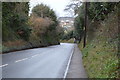
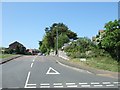
Dawlish : Teignmouth Road B3199
A bus stop on the right on the road between Dawlish and Teignmouth.
Image: © Lewis Clarke
Taken: 27 Mar 2011
0.12 miles
6

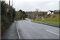
Leaving the Mounts, Dawlish
Shown from the other direction at http://www.geograph.org.uk/search.php?i=81945407 , this is the coast path leaving the clifftop park to follow the pavement by the A379.
Image: © Derek Harper
Taken: 25 Feb 2018
0.13 miles
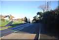
7

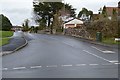
Footpath into gardens on the top of Lea Mount
The path leads from the coast road (A379 Teignmouth Road) into the gardens on Lea Mount
Image: © David Smith
Taken: 28 Apr 2011
0.14 miles