IMAGES TAKEN NEAR TO
Coronation Avenue, DAWLISH, EX7 9EH
Introduction
This page details the photographs taken nearby to Coronation Avenue, EX7 9EH by members of the Geograph project.
The Geograph project started in 2005 with the aim of publishing, organising and preserving representative images for every square kilometre of Great Britain, Ireland and the Isle of Man.

There are currently over 7.5m images from over14,400 individuals and you can help contribute to the project by visiting https://www.geograph.org.uk
Image Map (Loading...)


Getting Data...Please wait
Leaflet Map data © OpenStreetMap
Images are licensed for reuse under creativecommons.org/licenses/by-sa/2.0
Notes
- Clicking on the map will re-center to the selected point.
- The higher the marker number, the further away the image location is from the centre of the postcode.
Image Listing (61 Images Found)
Images are licensed for reuse under creativecommons.org/licenses/by-sa/2.0
Image
Details
Distance
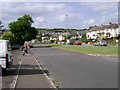
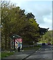
2
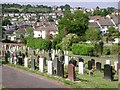
Looking across Third Avenue from Dawlish Cemetery
Image: © Robin Stott
Taken: 9 Jun 2009
0.14 miles

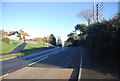
5
Dawlish : Teignmouth Road B3199
A bus stop on the right on the road between Dawlish and Teignmouth.
Image: © Lewis Clarke
Taken: 27 Mar 2011
0.15 miles
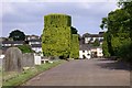
8
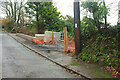
Wall replaces bank, Old Teignmouth Road, Dawlish
A stretch of old bank has gone beside the former main road, now used by the South West Coast Path.
Image: © Derek Harper
Taken: 12 Dec 2021
0.16 miles
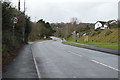
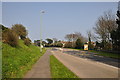
10
South West Coast Path on Old Teignmouth Road
The path follows a stretch of the old main road for over 500 metres, which forms a vehicular cul-de-sac entered from the far end. There are houses but they are discreetly hidden by trees. The modern A379 is a mere 29 metres off to the right here.
Image: © Derek Harper
Taken: 6 Oct 2019
0.16 miles