IMAGES TAKEN NEAR TO
Lower Meadow Rise, DAWLISH, EX7 9BX
Introduction
This page details the photographs taken nearby to Lower Meadow Rise, EX7 9BX by members of the Geograph project.
The Geograph project started in 2005 with the aim of publishing, organising and preserving representative images for every square kilometre of Great Britain, Ireland and the Isle of Man.

There are currently over 7.5m images from over14,400 individuals and you can help contribute to the project by visiting https://www.geograph.org.uk
Image Map (Loading...)


Getting Data...Please wait
Leaflet Map data © OpenStreetMap
Images are licensed for reuse under creativecommons.org/licenses/by-sa/2.0
Notes
- Clicking on the map will re-center to the selected point.
- The higher the marker number, the further away the image location is from the centre of the postcode.
Image Listing (111 Images Found)
Images are licensed for reuse under creativecommons.org/licenses/by-sa/2.0
Image
Details
Distance
1
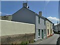
The Swan Inn, Weech Road, Dawlish
The lilac coloured house at this end of the range might not form part of the inn.
Image: © Stephen Craven
Taken: 14 Jul 2021
0.06 miles
2
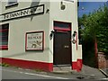
The Swan Inn, Weech Road, Dawlish - detail
A sign claims the inn dates from 1642, which may relate to an earlier building on the site. The present building is not listed and is likely to be rather younger than that. See Image for context.
Image: © Stephen Craven
Taken: 14 Jul 2021
0.06 miles
3
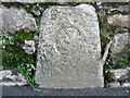
County Bridge Marker on Old Town Street, Dawlish
County Bridge Marker set in a stone wall on the south side of Old Town Street, 80 metres northeast of the bridge on Church Street in Dawlish parish. The stone marks the extent of roadway adjoining the bridge that the County was obliged to maintain.
Milestone Society National ID: DV_DAW01br
Image: © T Jenkinson
Taken: 31 Jan 2014
0.09 miles
4
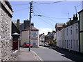
Brook House, Old Town Street, Dawlish
Probably a business premises. Wikipedia says that Brook House dates from c.1800, but I expect that relates to an older part of the building, glimpsed to the right of the part in the foreground.
Image: © Stephen Craven
Taken: 14 Jul 2021
0.09 miles
5
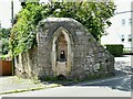
Drinking Fountain, Old Town Street, Dawlish
The fountain is inscribed 'Praise God from whom all blessings flow. C D March 1877'.
Image: © Stephen Craven
Taken: 14 Jul 2021
0.09 miles
6
Badlake Hill, Dawlish
Seen from Weech Road.
Image: © Robin Stott
Taken: 27 Jun 2009
0.10 miles
7

Bridge House, Church Street, Dawlish
Signed as Railway Convalescent Centre and run by the charity RCH http://www.rch.org.uk/
Image: © Robin Stott
Taken: 27 Jun 2009
0.10 miles
8
Junction of Park Road and Regent Street, Dawlish
Approached from Old Town Street.
Image: © Robin Stott
Taken: 7 Jun 2009
0.11 miles
9
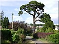
Pine and product, Manor Gardens, Dawlish
Image: © Robin Stott
Taken: 9 Jun 2009
0.11 miles
10
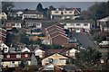
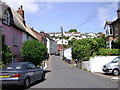
Dawlish : Houses on the hillside
Looking up towards the hillside from Church Street. The road seen here is Upper Longlands.
Image: © Lewis Clarke
Taken: 27 Mar 2011
0.11 miles