IMAGES TAKEN NEAR TO
Badlake Hill, DAWLISH, EX7 9BD
Introduction
This page details the photographs taken nearby to Badlake Hill, EX7 9BD by members of the Geograph project.
The Geograph project started in 2005 with the aim of publishing, organising and preserving representative images for every square kilometre of Great Britain, Ireland and the Isle of Man.

There are currently over 7.5m images from over14,400 individuals and you can help contribute to the project by visiting https://www.geograph.org.uk
Image Map
Images are licensed for reuse under creativecommons.org/licenses/by-sa/2.0
Notes
- Clicking on the map will re-center to the selected point.
- The higher the marker number, the further away the image location is from the centre of the postcode.
Image Listing (35 Images Found)
Images are licensed for reuse under creativecommons.org/licenses/by-sa/2.0
Image
Details
Distance
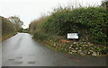
1

Junction on Langdon Lane
Long Lane (shown in Image) branches off to the left. It is a route with public access, a green lane that runs for several kilometres along the ridge north of the Dawlish Water valley. The "unsuitable for motor vehicles" sign is going to be completely obscured this spring unless some clearing takes place.
Image: © Derek Harper
Taken: 1 Feb 2017
0.03 miles
2
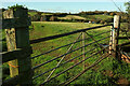
Farmland near Harvesters Farm
Image: © Derek Harper
Taken: 4 Nov 2020
0.04 miles
3
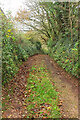
Lane to Westcote
A private drive leading down from Dawlish footpath 14.
Image: © Derek Harper
Taken: 12 Dec 2021
0.04 miles

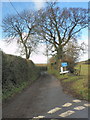
6
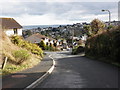
Badlake Hill
Passing the junction with The Humpy. From here on, the lane is rural.
Image: © Derek Harper
Taken: 12 Dec 2021
0.07 miles
8
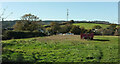
Field by The Humpy
Houses on the Humpy are on the left. This is a view from the gate shown in Image
Image: © Derek Harper
Taken: 4 Nov 2020
0.08 miles
10
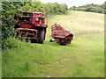
Dismantled Harvester
This harvester looks like it might have reached the end of its days.
Image: © Tony Atkin
Taken: 19 Jun 2011
0.09 miles