IMAGES TAKEN NEAR TO
Olive Grove, DAWLISH, EX7 0SY
Introduction
This page details the photographs taken nearby to Olive Grove, EX7 0SY by members of the Geograph project.
The Geograph project started in 2005 with the aim of publishing, organising and preserving representative images for every square kilometre of Great Britain, Ireland and the Isle of Man.

There are currently over 7.5m images from over14,400 individuals and you can help contribute to the project by visiting https://www.geograph.org.uk
Image Map
Images are licensed for reuse under creativecommons.org/licenses/by-sa/2.0
Notes
- Clicking on the map will re-center to the selected point.
- The higher the marker number, the further away the image location is from the centre of the postcode.
Image Listing (135 Images Found)
Images are licensed for reuse under creativecommons.org/licenses/by-sa/2.0
Image
Details
Distance
1

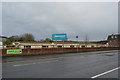
Warren Road, Dawlish Warren
Connecting most of the holiday camps to the beach. Hazelwood Park, left. Easton Wood, right of centre.
Image: © Robin Stott
Taken: 26 Sep 2009
0.04 miles

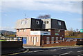
3

Peppermint Park holiday chalets, Dawlish Warren
Image: © Robin Stott
Taken: 26 Sep 2009
0.07 miles
4
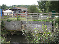
Shutterton Brook negotiates Hazelwood Park
Seen before it passes under Warren Road. Then it runs between two more holiday parks and under the railway before it reaches the River Exe.
Image: © Robin Stott
Taken: 26 Sep 2009
0.07 miles

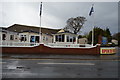
6

Devondale Court holiday flats, Dawlish Warren
Image: © Robin Stott
Taken: 26 Sep 2009
0.07 miles