IMAGES TAKEN NEAR TO
Sandalwood, DAWLISH, EX7 0SR
Introduction
This page details the photographs taken nearby to Sandalwood, EX7 0SR by members of the Geograph project.
The Geograph project started in 2005 with the aim of publishing, organising and preserving representative images for every square kilometre of Great Britain, Ireland and the Isle of Man.

There are currently over 7.5m images from over14,400 individuals and you can help contribute to the project by visiting https://www.geograph.org.uk
Image Map (Loading...)


Getting Data...Please wait
Leaflet Map data © OpenStreetMap
Images are licensed for reuse under creativecommons.org/licenses/by-sa/2.0
Notes
- Clicking on the map will re-center to the selected point.
- The higher the marker number, the further away the image location is from the centre of the postcode.
Image Listing (164 Images Found)
Images are licensed for reuse under creativecommons.org/licenses/by-sa/2.0
Image
Details
Distance

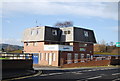
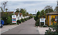
5

Dawlish Warren Road
The road describes long bends as it passes through holiday camp and guest house territory.
Image: © Derek Harper
Taken: 18 Jan 2015
0.03 miles

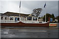
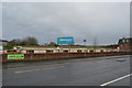
8

Warren Road, Dawlish Warren
Connecting most of the holiday camps to the beach. Hazelwood Park, left. Easton Wood, right of centre.
Image: © Robin Stott
Taken: 26 Sep 2009
0.03 miles

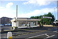
10
Welcome Family Holiday Park, Warren Road
Image: © Robin Stott
Taken: 26 Sep 2009
0.04 miles