IMAGES TAKEN NEAR TO
Bracken Way, DAWLISH, EX7 0SP
Introduction
This page details the photographs taken nearby to Bracken Way, EX7 0SP by members of the Geograph project.
The Geograph project started in 2005 with the aim of publishing, organising and preserving representative images for every square kilometre of Great Britain, Ireland and the Isle of Man.

There are currently over 7.5m images from over14,400 individuals and you can help contribute to the project by visiting https://www.geograph.org.uk
Image Map (Loading...)


Getting Data...Please wait
Leaflet Map data © OpenStreetMap
Images are licensed for reuse under creativecommons.org/licenses/by-sa/2.0
Notes
- Clicking on the map will re-center to the selected point.
- The higher the marker number, the further away the image location is from the centre of the postcode.
Image Listing (79 Images Found)
Images are licensed for reuse under creativecommons.org/licenses/by-sa/2.0
Image
Details
Distance
1
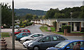
Hazelwood Park, Dawlish Warren
One of the most extensive of the holiday parks, reaching 600 metres and on average 200 metres wide back along the course of the Shutterton Brook.
Image: © Robin Stott
Taken: 26 Sep 2009
0.01 miles
2
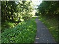
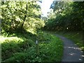
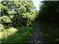
Path by Shutterton Brook (10)
The fence surrounds and protects a young tree
Image: © David Smith
Taken: 15 Sep 2019
0.08 miles
3

Peppermint Park holiday chalets, Dawlish Warren
Image: © Robin Stott
Taken: 26 Sep 2009
0.08 miles
4
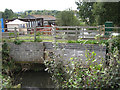
Shutterton Brook negotiates Hazelwood Park
Seen before it passes under Warren Road. Then it runs between two more holiday parks and under the railway before it reaches the River Exe.
Image: © Robin Stott
Taken: 26 Sep 2009
0.09 miles

8

Warren Road, Dawlish Warren
Connecting most of the holiday camps to the beach. Hazelwood Park, left. Easton Wood, right of centre.
Image: © Robin Stott
Taken: 26 Sep 2009
0.13 miles
9
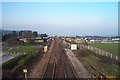
Railway near Dawlish Warren
The main railway between Exeter and Newton Abbot viewed from a bridge near to the Langstone Cliff Hotel. The sea lies just out of sight to the right. The buildings to the right are part of the large holiday complex of Dawlish Warren.
Image: © Richard Knights
Taken: 19 Jan 2001
0.13 miles
10
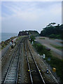
GWR, Dawlish Warren
At Dawlish Warren the GWR mainline railway reaches the mouth of the Exe estuary, at which point it passes Langstone Rock - also known as 'Red Rock', as seen in the centre of the image - before swinging west to run along the shore to Dawlish and Teignmouth; a picturesque stretch of line in summer, but one often hit by weather in winter.
Image: © Gwyn Jones
Taken: 27 Aug 2002
0.13 miles