IMAGES TAKEN NEAR TO
Buttercup Walk, DAWLISH, EX7 0FL
Introduction
This page details the photographs taken nearby to Buttercup Walk, EX7 0FL by members of the Geograph project.
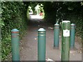
The Geograph project started in 2005 with the aim of publishing, organising and preserving representative images for every square kilometre of Great Britain, Ireland and the Isle of Man.

There are currently over 7.5m images from over14,400 individuals and you can help contribute to the project by visiting https://www.geograph.org.uk
Image Map
Images are licensed for reuse under creativecommons.org/licenses/by-sa/2.0
Notes
- Clicking on the map will re-center to the selected point.
- The higher the marker number, the further away the image location is from the centre of the postcode.
Image Listing (48 Images Found)
Images are licensed for reuse under creativecommons.org/licenses/by-sa/2.0
Image
Details
Distance
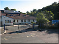
1
The bottom of Gatehouse Hill
The lower end of the hill is closed to vehicular traffic (if it was ever passable!). The other end of this section is Image
Image: © Robin Stott
Taken: 19 Jul 2009
0.01 miles
2

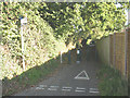
Gatehouse Hill (traffic free section)
This lower section of the road has been made traffic-free but is signed as a shared cycle/pedestrian route. I previously photographed this eleven years earlier Image Not much has changed since then apart from the removal of one bollard and the sides getting a bit overgrown.
Image: © Stephen Craven
Taken: 11 Jul 2021
0.02 miles
3
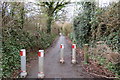
Gatehouse Hill - traffic-free section
This lower section of the road has been made traffic-free but is signed as a shared cycle/pedestrian route (the sign is nearly obscured by bushes at the left of the photo). For a photo of the other end of the section see Image
Image: © Stephen Craven
Taken: 26 Sep 2010
0.03 miles
4
Lane off Elm Grove Rd
The lane runs S-SW from Elm Grove Rd to Gatehouse Hill. No vehicles allowed, hence the bollards.
Image: © John C
Taken: 28 Mar 2018
0.04 miles
5
Gatehouse Hill / The Paddock, Dawlish
Shortly before the dead end of Gatehouse Hill.
Image: © Stephen Craven
Taken: 11 Jul 2021
0.05 miles
6
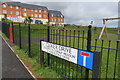
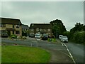
Play area and shops, Clover Drive
New housing and play area at the top end of Elm grove Road, Dawlish.
Image: © John C
Taken: 28 Mar 2018
0.07 miles
7
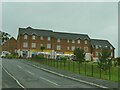
Premier stores, Clover Drive
One of a chain of convenience stores.
Image: © Stephen Craven
Taken: 11 Jul 2021
0.07 miles
8
Elm Grove Road play area
Photographed on a rainy evening with no-one about.
Image: © Stephen Craven
Taken: 11 Jul 2021
0.07 miles
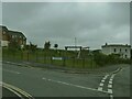
9
Gatehouse School entrance
A local authority primary school in Dawlish. For another view of the school see Image
Image: © Stephen Craven
Taken: 26 Sep 2010
0.08 miles
10
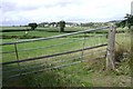
A sagging gate near Gatehouse Farm
Long views north of Dawlish are dominated by the off-white blocks of Langdon Hospital spread around its south-facing hillside Image
Image: © Robin Stott
Taken: 19 Jul 2009
0.08 miles