IMAGES TAKEN NEAR TO
Finistere Avenue, DAWLISH, EX7 0FH
Introduction
This page details the photographs taken nearby to Finistere Avenue, EX7 0FH by members of the Geograph project.
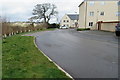
The Geograph project started in 2005 with the aim of publishing, organising and preserving representative images for every square kilometre of Great Britain, Ireland and the Isle of Man.

There are currently over 7.5m images from over14,400 individuals and you can help contribute to the project by visiting https://www.geograph.org.uk
Image Map
Images are licensed for reuse under creativecommons.org/licenses/by-sa/2.0
Notes
- Clicking on the map will re-center to the selected point.
- The higher the marker number, the further away the image location is from the centre of the postcode.
Image Listing (37 Images Found)
Images are licensed for reuse under creativecommons.org/licenses/by-sa/2.0
Image
Details
Distance
1
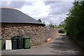
Gatehouse Cottages beyond Gatehouse Farm, off Secmaton Lane
The lane bends to the left. A track to the cottages climbs up to the right. The farm buildings, left, appear to be undergoing extensive residential redevelopment.
Image: © Robin Stott
Taken: 19 Jul 2009
0.07 miles
2

Morlaix Close, Dawlish
New housing development.
Image: © John C
Taken: 28 Mar 2018
0.09 miles
3
Path behind Dawlish Leisure Centre
The path crosses an open playing field towards Exeter Road.
Image: © Stephen Craven
Taken: 27 Oct 2019
0.10 miles
4
Roscoff Road, Dawlish
Housing further along Roscoff Road.
Image: © John C
Taken: 28 Mar 2018
0.11 miles
5
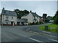
Roscoff Road
The roads on this modern housing estate are all named after places in Brittany.
Image: © Stephen Craven
Taken: 11 Jul 2021
0.11 miles
6

Secmaton Lane cycleway
A 400 metre section of Secmaton Lane has been made into a traffic-free route running between one modern housing estate and another still under construction.
Image: © Stephen Craven
Taken: 11 Jul 2021
0.14 miles
7
Roscoff Road, Dawlish
Towards the Elm Grove Road end.
Image: © John C
Taken: 28 Mar 2018
0.14 miles
8
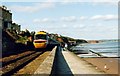
Dawlish Sea Wall
One of the most picturesque stretches of railway line in the UK. The large sandstone block in the distance is Langstone Rock.
Image: © Michael Parry
Taken: Unknown
0.14 miles
9

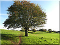
Path junction in Elm Grove woods
This woodland is shown as a plantation on maps from 1905 or earlier, but is now a mature deciduous woodland. Location approximate (+/- 30m) as paths in this wood are not shown on any maps.
Image: © Stephen Craven
Taken: 27 Oct 2019
0.14 miles
10

Sports pitch behind Dawlish Leisure Centre
A levelled area, presumably for ball games.
Image: © Stephen Craven
Taken: 27 Oct 2019
0.15 miles