IMAGES TAKEN NEAR TO
Heywood Drive, EXETER, EX6 8SD
Introduction
This page details the photographs taken nearby to Heywood Drive, EX6 8SD by members of the Geograph project.
The Geograph project started in 2005 with the aim of publishing, organising and preserving representative images for every square kilometre of Great Britain, Ireland and the Isle of Man.

There are currently over 7.5m images from over14,400 individuals and you can help contribute to the project by visiting https://www.geograph.org.uk
Image Map
Images are licensed for reuse under creativecommons.org/licenses/by-sa/2.0
Notes
- Clicking on the map will re-center to the selected point.
- The higher the marker number, the further away the image location is from the centre of the postcode.
Image Listing (236 Images Found)
Images are licensed for reuse under creativecommons.org/licenses/by-sa/2.0
Image
Details
Distance
1
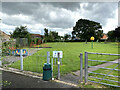
Playing park off Well Street, Starcross
Provided by Starcross Parish Council. Next door, out of shot right, is Starcross Bowling Club.
Image: © Robin Stott
Taken: 1 Aug 2021
0.10 miles
2
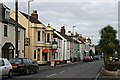
The northern end of the Strand
This is just opposite the railway station. The cream building is the Atmospheric Railway Inn which has a lot of old railway memorabilia and photographs.
Image: © Tony Atkin
Taken: 27 Jan 2007
0.12 miles
3
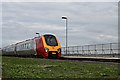
Just Passing Through
A voyager train is travelling at speed through Starcross railway station. This station is served by a local two carriage service between Exeter and Paignton but the sound of fast services travelling between Exeter and Plymouth is a feature of Starcross Strand.
Image: © Tony Atkin
Taken: 27 Jan 2007
0.12 miles
4
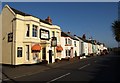
The Strand, Starcross
This row of houses and pub face the Exe estuary, although they are separated from it by the A379 and the railway.
Image: © Derek Harper
Taken: 14 Apr 2008
0.12 miles
5
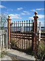
Gate by the railway, Starcross
Unlike the one at the foot crossing shown in Image, this one, closer to the station, is securely locked. Beyond the track is the Exe estuary.
Image: © Derek Harper
Taken: 26 Sep 2010
0.12 miles
6
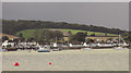
Starcross from the estuary
From a passenger ferry leaving the River Exe Cafe. Warboro Plantation sits on the hill.
Image: © Derek Harper
Taken: 26 Sep 2019
0.12 miles
7

Wallace and Gromit, Starcross
The famous partnership finds itself on a rooftop in Well Street.
Image: © Derek Harper
Taken: 15 Apr 2009
0.14 miles
8
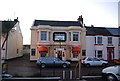
The Atmospheric Railway, Starcross
Public house named after Brunel's railway.
Image: © N Chadwick
Taken: 2 Jan 2009
0.14 miles
9

Starcross Station and the Exe Estuary and birdwatchers
A coachload of RSPB Stourbridge members were at the station when I visited. They had telescopes, tripods, and long telephoto lenses. This railway station also has the jetty for a ferry to Exmouth.
Image: © David Hawgood
Taken: 20 Nov 2005
0.14 miles
10
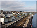
Starcross - sea, railway and village street
The railway follows the shore of the Exe Estuary, and is the exposed to the open sea at Dawlish before turning inland to Newton Abbott. The houses, shops and public houses of the village seen beyond the railway are along the narrow A379 road from Exeter to Dawlish.
Image: © David Hawgood
Taken: 20 Nov 2005
0.14 miles