IMAGES TAKEN NEAR TO
Swan Road, EXETER, EX6 8QW

Introduction

This page details the photographs taken nearby to Swan Road, EX6 8QW by members of the Geograph project.

The Geograph project started in 2005 with the aim of publishing, organising and preserving representative images for every square kilometre of Great Britain, Ireland and the Isle of Man.

There are currently over 7.5m images from over14,400 individuals and you can help contribute to the project by visiting https://www.geograph.org.uk

Image Map


Images are licensed for reuse under creativecommons.org/licenses/by-sa/2.0
Notes
  • Clicking on the map will re-center to the selected point.
  • The higher the marker number, the further away the image location is from the centre of the postcode.

Image Listing (85 Images Found)

Images are licensed for reuse under creativecommons.org/licenses/by-sa/2.0
  • ...
Image
Details
Distance
1
Playing field
Seen from Church Street.
Image: © Michael Dibb Taken: 1 Jun 2017
0.05 miles
2
Exmouth : Exe Estuary
Looking towards Starcross and the Exe estuary from Exmouth.
Image: © Lewis Clarke Taken: 22 Oct 2013
0.06 miles
3
Courtenay Arms, Star Cross, Devonshire
Image: © Tom Courtney Taken: Unknown
0.06 miles
4
Starcross and the Exe estuary
From Staplake Lane, with Tiverland Farm on the left, looking over Starcross and the Exe estuary to Exmouth. The gasholder on Albion Hill is conspicuous.
Image: © Derek Harper Taken: Unknown
0.08 miles
5
Starcross Primary School
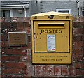
A mostly modern school. If you want to see a closer view of that yellow box set in the wall look here:- Image
Image: © Tony Atkin Taken: 27 Jan 2007
0.08 miles
6
French Post Box
Set into the wall of Starcross Primary School is this French post box. Post your mail here and it will get collected by the Royal Mail. If you look around the lock you will see that it has been adapted to have a Royal Mail lock fitted. The plaque on the left explains that it was a gift from the people of Henvic in Brittany.
Image: © Tony Atkin Taken: 27 Jan 2007
0.08 miles
7
Church Street, Starcross
A prosperous looking row of terraced houses.
Image: © Tony Atkin Taken: 27 Jan 2007
0.08 miles
8
St Paul's Church, Starcross
Image: © Tony Atkin Taken: 27 Jan 2007
0.08 miles
9
Starcross and the mouth of the Exe
The view, from close to Warboro Plantation, is referred to in Image Farmland descends to the southern part of Starcross. Beyond, the Exe sweeps around between Great Bull Hill Sand and Dawlish Warren (a line of boats marks the main channel) to reach the sea, with Exmouth on the left.
Image: © Derek Harper Taken: Unknown
0.10 miles
10
Parish church [1]
The church of St Paul was built 1828 and much altered in 1854. Listed, grade II, with details at: https://www.historicengland.org.uk/listing/the-list/list-entry/1306581
Image: © Michael Dibb Taken: 1 Jun 2017
0.12 miles
  • ...