IMAGES TAKEN NEAR TO
Fore Street, EXETER, EX6 8LD
Introduction
This page details the photographs taken nearby to Fore Street, EX6 8LD by members of the Geograph project.
The Geograph project started in 2005 with the aim of publishing, organising and preserving representative images for every square kilometre of Great Britain, Ireland and the Isle of Man.

There are currently over 7.5m images from over14,400 individuals and you can help contribute to the project by visiting https://www.geograph.org.uk
Image Map
Images are licensed for reuse under creativecommons.org/licenses/by-sa/2.0
Notes
- Clicking on the map will re-center to the selected point.
- The higher the marker number, the further away the image location is from the centre of the postcode.
Image Listing (85 Images Found)
Images are licensed for reuse under creativecommons.org/licenses/by-sa/2.0
Image
Details
Distance
1
Fore Street, Kenton
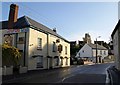
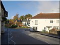
The A379 just east of The Green, climbing up a terrace of the Kenn valley. This is an awkward stretch of a busy main road for pedestrians and motorists. The zigzag white lines indicate the proximity of a pedestrian crossing behind the camera. On the left is the former Devon Arms, since 2007 the Chi oriental restaurant.
Image: © Derek Harper
Taken: 4 Nov 2009
0.01 miles
4
The triangle at Kenton
The A379 changes here from Exeter Hill to Fore Street at the junction with Church Street
Image: © David Smith
Taken: 28 Apr 2011
0.03 miles
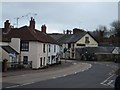
5
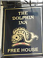
Fore Street, Kenton (2)
Looking in the other direction from the same spot as Image, with the pedestrian crossing mentioned and a sharp right bend in the A379 as it runs past The Green. On the left is the Dolphin, surviving as a pub unlike the Devon Arms almost opposite. On the right is a hair and beauty salon.
Image: © Derek Harper
Taken: 4 Nov 2009
0.03 miles
6
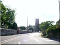
Kenton : Fore Street & All Saints Church
Image: © Lewis Clarke
Taken: 1 Jun 2009
0.03 miles
7

Don't even think of parking here
Well, actually, it hadn't occurred to me until I saw this notice. This is by Image
Image: © Derek Harper
Taken: 4 Nov 2009
0.03 miles
8
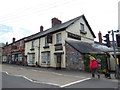
The centre of Kenton
On the left is a hairdressers, and opposite is the Dolphin Inn with advertising on the roof of the annexe
Image: © David Smith
Taken: 23 Jan 2012
0.03 miles
9
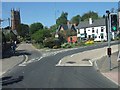
The Triangle Kenton
This photograph is taken from Fore Street facing the remains of an old cross and looking behind to the A379 Exeter Road and the houses beyond.
Image: © Sarah Smith
Taken: 5 Nov 2009
0.03 miles
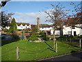
10

The Green, Kenton
From Teignbridge's Conservation Area Character Appraisal for Kenton at http://www.teignbridge.gov.uk/CHttpHandler.ashx?id=3768&p=0 : "a fine example of planned village open space ... The most significant change to the layout of the village centre followed a major fire in 1856. As part of the re-development the triangular green was created and the cross erected in 1888. Views of the Church from Fore Street were opened up and framed by the new buildings. Consequently the eastern end of Church Street is very different to its former arrangement. The 1840 tithe map shows tightly packed cottages which suggests a more intimate and typically Devonian village streetscene than exists today. In its place however, the village gained a distinctive, Victorian development with a plan which emphasises the Church at the heart of the community."
This scene appears in the background to Image
Image: © Derek Harper
Taken: 4 Nov 2009
0.04 miles