IMAGES TAKEN NEAR TO
Kenton, EXETER, EX6 8HQ
Introduction
This page details the photographs taken nearby to EX6 8HQ by members of the Geograph project.
The Geograph project started in 2005 with the aim of publishing, organising and preserving representative images for every square kilometre of Great Britain, Ireland and the Isle of Man.

There are currently over 7.5m images from over14,400 individuals and you can help contribute to the project by visiting https://www.geograph.org.uk
Image Map
Images are licensed for reuse under creativecommons.org/licenses/by-sa/2.0
Notes
- Clicking on the map will re-center to the selected point.
- The higher the marker number, the further away the image location is from the centre of the postcode.
Image Listing (12 Images Found)
Images are licensed for reuse under creativecommons.org/licenses/by-sa/2.0
Image
Details
Distance
1
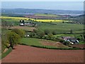
Countryside around Pitt Farm
A detail of the scene in Image; Pitt Farm is on the right. Left of centre is New House Farm, in Image Again, the Exe estuary is in the distance.
Image: © Derek Harper
Taken: 21 Apr 2009
0.07 miles
2
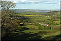
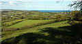
Towards the Exe estuary
From the junction where the green lanes shown in Image meet. Right of centre is Pitt Farm. In shadow on the left is New House Farm; across to the right is the hamlet of Gulliford. Beyond the oilseed rape is Easter Hill, and across the estuary is Exmouth.
Image: © Derek Harper
Taken: 6 May 2021
0.08 miles
3
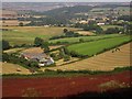
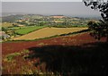
Pitt Farm
A detail of Image, showing the pair of colourful tractors, as well as the red sorrel in the nearest field. The farmhouse at Pitt Farm is a "very unspoiled traditional farmhouse" http://www.britishlistedbuildings.co.uk/en-85958-pitt-farmhouse-mamhead .
Image: © Derek Harper
Taken: 10 Aug 2012
0.12 miles
4
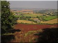
View over Pitt Farm
A detail of the scene in Image (and more closely resembling Image), in contrasting lighting and a different time of year, taken from more or less the same spot. The ploughed field in the foreground of the older photos is now a blaze of red sorrel - perhaps a fallow year. Up to the left from Pitt Farm is New House Farm, in Image It's quite hard to make out the Exe estuary in the hazy distance.
Image: © Derek Harper
Taken: 10 Aug 2012
0.15 miles
5
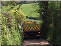
Blocked lane
See Image I never fathomed how many vehicles were involved. Apparently the lane had been straightforward, but the tight crossroads where it meets the lane to Larkbeare Farm was proving a problem. It was going to be clear in "ten minutes", but after a quarter of an hour I gave up and went another way.
Image: © Derek Harper
Taken: 21 Apr 2009
0.17 miles
6
Countryside north of Dawlish
Looking right from Image], with Cofton on the left and parts of the settlement of Dawlish Warren to the right.
Image: © Derek Harper
Taken: 6 May 2021
0.18 miles
7
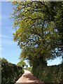
Oak trees by the lane
From further down Image, looking up the fresh surface, beneath newly-leafed oaks.
Image: © Derek Harper
Taken: 21 Apr 2009
0.19 miles
8
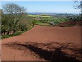
Field above Pitt Farm
The field is bordered by the green lane shown in Image (just off to the right) and the green lane on the left descending from it to Pitt Farm, right of centre. In the distance is the Exe estuary.
Image: © Derek Harper
Taken: 21 Apr 2009
0.20 miles
9
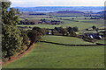
Farmland, Pitt Farm
Looking more to the right than Image and Image, again with field of red sorrel in the foreground, and with the sea right of centre.
Image: © Derek Harper
Taken: 10 Aug 2012
0.20 miles
10
Towards New House Farm, 1997
Taken a few metres to the right of Image] and with the view to the left opening up, making this similar to Image New House Farm is in the centre. The prominent white gable belongs to Hillhead. Just on the left is the public access route following a track down to Pitt Farm (on the right).
Image: © Derek Harper
Taken: 12 Oct 1997
0.22 miles