IMAGES TAKEN NEAR TO
Kennford, EXETER, EX6 7XY
Introduction
This page details the photographs taken nearby to EX6 7XY by members of the Geograph project.
The Geograph project started in 2005 with the aim of publishing, organising and preserving representative images for every square kilometre of Great Britain, Ireland and the Isle of Man.

There are currently over 7.5m images from over14,400 individuals and you can help contribute to the project by visiting https://www.geograph.org.uk
Image Map
Images are licensed for reuse under creativecommons.org/licenses/by-sa/2.0
Notes
- Clicking on the map will re-center to the selected point.
- The higher the marker number, the further away the image location is from the centre of the postcode.
Image Listing (13 Images Found)
Images are licensed for reuse under creativecommons.org/licenses/by-sa/2.0
Image
Details
Distance
1
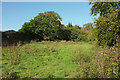
Field, Splatford
A small meadow beside Splatford House, with farm buildings on the left.
Image: © Derek Harper
Taken: 25 Sep 2018
0.08 miles
2

Towards Pope's Copse
Looking left from where Image] was taken, with the lane to Splatford on the extreme left.
Image: © Derek Harper
Taken: 25 Sep 2018
0.12 miles
3
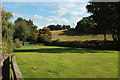
Field, Splatford
A neat lawn on the other side of the lane from Image
Image: © Derek Harper
Taken: 25 Sep 2018
0.13 miles
4

Entrance to Country View Farm, near Splatford
Image: © David Gearing
Taken: 20 Sep 2013
0.13 miles
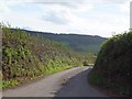
5

Lane near Splatford
Looking west down the lane close to the A38/A380 junction, towards the farm of Splatford Barton.
Image: © Derek Harper
Taken: 18 Apr 2006
0.14 miles
7

View near Splatford
Looking south from the lane west of Splatford Barton, in the direction of Brown's Farm (hidden), with the Haldon Hills rising ahead. 7:31 am.
Image: © Derek Harper
Taken: 18 Apr 2006
0.15 miles
8

Ploughed field near Country View farm
Taken a little west of Image], and of the junction with the lane to Brown's Farm, behind the hedge. The background view is similar.
Image: © Derek Harper
Taken: 25 Sep 2018
0.16 miles
9

Minor road passing Brown's Farm
The verge on the left has been cut back to allow traffic from the farm to see vehicles on the minor road
Image: © David Smith
Taken: 18 Oct 2011
0.16 miles
10

Stream, Splatford
A tributary of the River Kenn that has gathered waters from the Haldon hills in the background heads towards the camera. The nearer horse must be very close to the easting gridline. Taken from the foot of the hill shown in Image
Image: © Derek Harper
Taken: 6 May 2008
0.17 miles