IMAGES TAKEN NEAR TO
Bay Trees, EXETER, EX6 7UY
Introduction
This page details the photographs taken nearby to Bay Trees, EX6 7UY by members of the Geograph project.
The Geograph project started in 2005 with the aim of publishing, organising and preserving representative images for every square kilometre of Great Britain, Ireland and the Isle of Man.

There are currently over 7.5m images from over14,400 individuals and you can help contribute to the project by visiting https://www.geograph.org.uk
Image Map
Images are licensed for reuse under creativecommons.org/licenses/by-sa/2.0
Notes
- Clicking on the map will re-center to the selected point.
- The higher the marker number, the further away the image location is from the centre of the postcode.
Image Listing (20 Images Found)
Images are licensed for reuse under creativecommons.org/licenses/by-sa/2.0
Image
Details
Distance
1

Welcome to Kennford
In the Parish of Kenn.
Image: © Anthony Vosper
Taken: 18 Sep 2010
0.02 miles
2

Turning to Kenn and Kennford from the A38, west-bound
Image: © Rob Purvis
Taken: 4 Oct 2009
0.06 miles

4

X46 on the A38
I took this photo to try and see whether the approaching bus, over 300 metres away, was indeed an X46, but was still struggling to enlarge the image when the vehicle was upon me. Fortunately, the driver deduced that I wanted to get on.
Image: © Derek Harper
Taken: 10 Feb 2014
0.07 miles
5
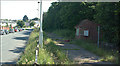
Dept of Transport Vehicle Weighbridge, Kennford.
No longer in use, this weighbridge is typical of the type used for carrying out spot checks on commercial vehicles. It weighs each axle individually and if the vehicle is overweight on any axle, the vehicle may be prohibited from continuing until the problem is rectified. Safety checks are also carried out at these sites.
Image: © Mike Crowe
Taken: 8 Jun 2005
0.08 miles
7
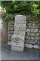
Old Milestone by the former A38, Kennford Village
Carved stone post by the UC road (was A38), in parish of KENN (TEIGNBRIDGE District), Kennford village, 20m SW of Kennford Garage, opposite drive to Southlands / Westfield, on pavement against wall, near telegraph pole, on East side of road. Exeter granite facets, erected by the Exeter turnpike trust in the 19th century.
Inscription reads:-
: 6 / Miles to / Chudleigh / 4 / Miles to / Exeter : : 180 / Miles / to / London : : 4 / Miles to / Exeter / 6 / Miles to / Chudleigh :
Carved benchmark and rivet on angled base.
Grade II listed. List Entry Number: 1440323
https://historicengland.org.uk/listing/the-list/list-entry/1440323
Milestone Society National ID: DV_EXCH04.
Image: © Alan Rosevear
Taken: 18 Apr 2011
0.09 miles
8
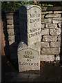
Milestone, Kennford
A reminder that the main village street was once the main road, which now thunders some 200 metres away.
Image: © Derek Harper
Taken: 25 Sep 2007
0.10 miles
9
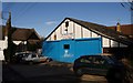
Kennford Garage
The famous Wobbly Wheel garage may have gone, but the Kennford Garage remains on Main Road.
Image: © Derek Harper
Taken: 25 Sep 2007
0.11 miles
10
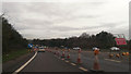
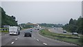
Teignbridge : The A38
The A38 with some roadworks taking place.
Image: © Lewis Clarke
Taken: 16 Dec 2014
0.13 miles