IMAGES TAKEN NEAR TO
Longdown, EXETER, EX6 7RS
Introduction
This page details the photographs taken nearby to EX6 7RS by members of the Geograph project.
The Geograph project started in 2005 with the aim of publishing, organising and preserving representative images for every square kilometre of Great Britain, Ireland and the Isle of Man.

There are currently over 7.5m images from over14,400 individuals and you can help contribute to the project by visiting https://www.geograph.org.uk
Image Map
Images are licensed for reuse under creativecommons.org/licenses/by-sa/2.0
Notes
- Clicking on the map will re-center to the selected point.
- The higher the marker number, the further away the image location is from the centre of the postcode.
Image Listing (7 Images Found)
Images are licensed for reuse under creativecommons.org/licenses/by-sa/2.0
Image
Details
Distance
1

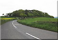
Junction of Vicarage Lane with B3212, Longdown
Image: © David Smith
Taken: 24 Oct 2017
0.02 miles
2
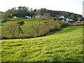
Vicarage Lane, Longdown from Perridge Cross
Near Longdown (of which these houses form a detached "suburb") the B3212 crosses a col between the Exe and Teign watersheds; the fields in the foreground drop west to the Teign.
Image: © Derek Harper
Taken: 27 Apr 2006
0.03 miles
3
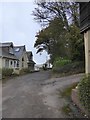
Vicarage Lane, Longdown
As one might expect with fewer clergy, this no longer leads to a vicarage, but to the former vicarage
Image: © David Smith
Taken: 24 Oct 2017
0.05 miles

6

Track in Eastern Cotley Wood
On a walk with permission of the Perridge Estate
Image: © David Smith
Taken: 24 Oct 2017
0.20 miles
7
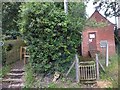
Path and old telephone exchange
The path avoids the descent into the village and is a short cut to Perridge Cross
Image: © David Smith
Taken: 31 Jul 2012
0.25 miles