IMAGES TAKEN NEAR TO
Layne Close, EXETER, EX6 7QD
Introduction
This page details the photographs taken nearby to Layne Close, EX6 7QD by members of the Geograph project.
The Geograph project started in 2005 with the aim of publishing, organising and preserving representative images for every square kilometre of Great Britain, Ireland and the Isle of Man.

There are currently over 7.5m images from over14,400 individuals and you can help contribute to the project by visiting https://www.geograph.org.uk
Image Map
Images are licensed for reuse under creativecommons.org/licenses/by-sa/2.0
Notes
- Clicking on the map will re-center to the selected point.
- The higher the marker number, the further away the image location is from the centre of the postcode.
Image Listing (24 Images Found)
Images are licensed for reuse under creativecommons.org/licenses/by-sa/2.0
Image
Details
Distance

3
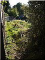
Footpath in Christow
Christow Footpath 7 begins rather obscurely by climbing between a fence and a stream as it leaves Village Road.
Image: © Derek Harper
Taken: 5 Oct 2007
0.10 miles
4
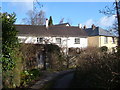
Cottages at the Mill, Christow
A footpath winds between these cottages grouped round a former mill in Christow.
Image: © Derek Harper
Taken: 17 Apr 2006
0.11 miles


7

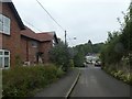
New housing in Wet Lane
Where the houses are there used to be a garage and a shop
Image: © John Firth
Taken: 27 Oct 2015
0.13 miles

10

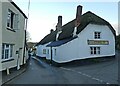
Wet lane and Caversham Close, Christow
Image: © David Smith
Taken: 15 Jul 2020
0.14 miles