IMAGES TAKEN NEAR TO
Foxhole Hill, EXETER, EX6 7PJ
Introduction
This page details the photographs taken nearby to Foxhole Hill, EX6 7PJ by members of the Geograph project.
The Geograph project started in 2005 with the aim of publishing, organising and preserving representative images for every square kilometre of Great Britain, Ireland and the Isle of Man.

There are currently over 7.5m images from over14,400 individuals and you can help contribute to the project by visiting https://www.geograph.org.uk
Image Map
Images are licensed for reuse under creativecommons.org/licenses/by-sa/2.0
Notes
- Clicking on the map will re-center to the selected point.
- The higher the marker number, the further away the image location is from the centre of the postcode.
Image Listing (2 Images Found)
Images are licensed for reuse under creativecommons.org/licenses/by-sa/2.0
Image
Details
Distance
1

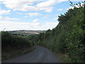
Foxhole Hill, lined with trees and hedges
Image: © David Smith
Taken: 15 Jul 2020
0.08 miles
2
Steep hill below Christow
Looking downhill, the map has a single arrow implying a gradient of between 14% and 20%.
Image: © Stephen Craven
Taken: 26 Aug 2016
0.14 miles