IMAGES TAKEN NEAR TO
Dry Lane, EXETER, EX6 7PH
Introduction
This page details the photographs taken nearby to Dry Lane, EX6 7PH by members of the Geograph project.
The Geograph project started in 2005 with the aim of publishing, organising and preserving representative images for every square kilometre of Great Britain, Ireland and the Isle of Man.

There are currently over 7.5m images from over14,400 individuals and you can help contribute to the project by visiting https://www.geograph.org.uk
Image Map
Images are licensed for reuse under creativecommons.org/licenses/by-sa/2.0
Notes
- Clicking on the map will re-center to the selected point.
- The higher the marker number, the further away the image location is from the centre of the postcode.
Image Listing (16 Images Found)
Images are licensed for reuse under creativecommons.org/licenses/by-sa/2.0
Image
Details
Distance
1
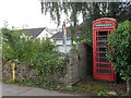
Phone box and broken road sign in Christow
The old red phone box, although like many such structures grade 2 listed, is not being kept in good repair.
Next to it is a finger post sign, with one arm (pointing to Kennick Reservoir and Torquay) Image hanging downwards.
Image: © Stephen Craven
Taken: 26 Aug 2016
0.05 miles

3
Corner of Dry Lane and Commons Hill, Christow
The building on the corner bears three interesting features: a postbox set into the wall; a sign for a firm of builders; and a small stone plaque with the legend "134 m". A visitor to this site has explained that the latter was introduced by local author and geographer Stafford Clark many years ago, and the line signifies 134 metres above sea level at that point.
Image: © Stephen Craven
Taken: 26 Aug 2016
0.06 miles

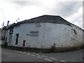
6

Former baptist chapel off Dry Lane, Christow (1)
The chapel has been converted for residential use.
Image: © Stephen Craven
Taken: 26 Aug 2016
0.08 miles
7

Former baptist chapel off Dry Lane, Christow (2)
The chapel has been converted for residential use.
Image: © Stephen Craven
Taken: 26 Aug 2016
0.08 miles
8

Bottom of Commons Hill near Christow
The sign shows a gradient of 16% ahead.
Image: © Stephen Craven
Taken: 26 Aug 2016
0.09 miles

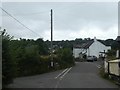
10

New housing in Wet Lane
Where the houses are there used to be a garage and a shop
Image: © John Firth
Taken: 27 Oct 2015
0.10 miles