IMAGES TAKEN NEAR TO
Great Mead, EXETER, EX6 7EZ
Introduction
This page details the photographs taken nearby to Great Mead, EX6 7EZ by members of the Geograph project.
The Geograph project started in 2005 with the aim of publishing, organising and preserving representative images for every square kilometre of Great Britain, Ireland and the Isle of Man.

There are currently over 7.5m images from over14,400 individuals and you can help contribute to the project by visiting https://www.geograph.org.uk
Image Map
Images are licensed for reuse under creativecommons.org/licenses/by-sa/2.0
Notes
- Clicking on the map will re-center to the selected point.
- The higher the marker number, the further away the image location is from the centre of the postcode.
Image Listing (72 Images Found)
Images are licensed for reuse under creativecommons.org/licenses/by-sa/2.0
Image
Details
Distance
1
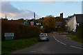
Dunsford : Briton Street Lane
Looking up the lane as it heads through Dunsford.
Image: © Lewis Clarke
Taken: 6 Nov 2016
0.01 miles
2
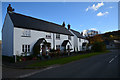
Dunsford : Briton Street Lane
Houses alongside the road in the village.
Image: © Lewis Clarke
Taken: 6 Nov 2016
0.02 miles

5
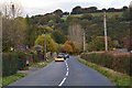
Dunsford : The B3212
Looking along the road as it heads beside Dunsford.
Image: © Lewis Clarke
Taken: 6 Nov 2016
0.09 miles
6
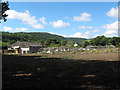
Abandoned nursery near Dunsford
Lots of empty glasshouses.
Image: © Stephen Craven
Taken: 26 Aug 2016
0.15 miles
7
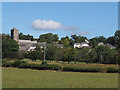
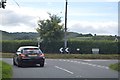
View towards Dunsford village
From a public footpath.
Image: © Stephen Craven
Taken: 26 Aug 2016
0.16 miles
8

Wooden stile on the path to Dunsford
Image: © Stephen Craven
Taken: 26 Aug 2016
0.17 miles
9
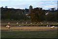
Dunsford : Grassy Field & Sheep
Sheep grazing in a grassy field with Dunsford in the background.
Image: © Lewis Clarke
Taken: 6 Nov 2016
0.17 miles
