IMAGES TAKEN NEAR TO
Doddiscombsleigh, EXETER, EX6 7BN
Introduction
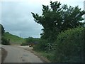
This page details the photographs taken nearby to EX6 7BN by members of the Geograph project.
The Geograph project started in 2005 with the aim of publishing, organising and preserving representative images for every square kilometre of Great Britain, Ireland and the Isle of Man.

There are currently over 7.5m images from over14,400 individuals and you can help contribute to the project by visiting https://www.geograph.org.uk
Image Map
Images are licensed for reuse under creativecommons.org/licenses/by-sa/2.0
Notes
- Clicking on the map will re-center to the selected point.
- The higher the marker number, the further away the image location is from the centre of the postcode.
Image Listing (11 Images Found)
Images are licensed for reuse under creativecommons.org/licenses/by-sa/2.0
Image
Details
Distance
1
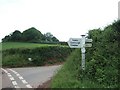
Willhayes Cross
It looks as if the direction arms on the sign at the crossroads date from different periods, with two kinds of lettering.
Image: © David Smith
Taken: 30 May 2011
0.02 miles
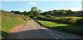
2

Willhayes Cross
A reverse view of Image, confirming the discrepancy between the arms. Perhaps the original right-hand one was knocked off by a passing lorry. The lane ahead to Penhill Cross carries the parish boundary between Dunchideock (left) and Doddiscombsleigh.
Image: © Derek Harper
Taken: 25 Sep 2018
0.02 miles
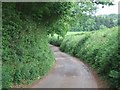
3
Lane at Willhayes Cross
The view in Image without the signpost. The lane, carrying the parish boundary between Dunchideock (left) and Doddiscombsleigh, crosses into Image around where the splayed hedge meets it. Beyond is Valley View Farm.
Image: © Derek Harper
Taken: 25 Sep 2018
0.05 miles
4
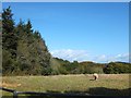
The road to Windy Cross
The road leads through South Wood, visible on the right horizon
Image: © David Smith
Taken: 30 May 2011
0.06 miles
5
The road to Sexton's Cross down Willhayes Hill
Image: © David Smith
Taken: 30 May 2011
0.07 miles
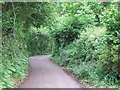
7
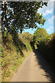
Willhayes Hill
Looking in the opposite direction, up the hill, from where Image was taken.
Image: © Derek Harper
Taken: 25 Sep 2018
0.23 miles
8
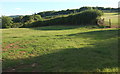
Field boundary by Ashlake Cross
Looking right from where Image] was taken.
Image: © Derek Harper
Taken: 25 Sep 2018
0.24 miles
9
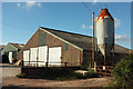
Farm buildings, Ashlake Cross
At a corner on the lane between Willhayes Cross and Leachway Lane Cross.
Image: © Derek Harper
Taken: 25 Sep 2018
0.24 miles
10
Farm entrance at Ashlake Cross
Ashlake Cross is only a sharp bend in the road. There is no road junction.
Image: © David Smith
Taken: 30 May 2011
0.24 miles