IMAGES TAKEN NEAR TO
Longdown, EXETER, EX6 7BD
Introduction
This page details the photographs taken nearby to EX6 7BD by members of the Geograph project.
The Geograph project started in 2005 with the aim of publishing, organising and preserving representative images for every square kilometre of Great Britain, Ireland and the Isle of Man.

There are currently over 7.5m images from over14,400 individuals and you can help contribute to the project by visiting https://www.geograph.org.uk
Image Map
Images are licensed for reuse under creativecommons.org/licenses/by-sa/2.0
Notes
- Clicking on the map will re-center to the selected point.
- The higher the marker number, the further away the image location is from the centre of the postcode.
Image Listing (8 Images Found)
Images are licensed for reuse under creativecommons.org/licenses/by-sa/2.0
Image
Details
Distance
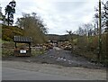
1

Culver House
An early (1835) neo-Tudor house in the valley of the Culver Brook (foreground), seen from the B3212.
Image: © Derek Harper
Taken: 4 May 2006
0.07 miles
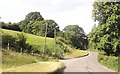
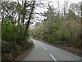
2
B3212 towards Exeter
Along the valley of the Culver Brook, which is down on the left.
Image: © Robin Webster
Taken: 7 Sep 2019
0.10 miles
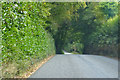
5
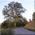
Solitary tree by B3212
The tree marks the end of the drive to Culver House (which dates from the 19th century) Image
Image: © David Smith
Taken: 31 Oct 2014
0.14 miles
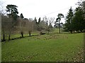
6
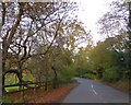
B3212 passing the grounds of Culver House
The house Image is on the opposite bank of the valley of the Culver Brook, where the sheep are grazing
Image: © David Smith
Taken: 31 Oct 2014
0.14 miles